Hurricane Rafael (2012)
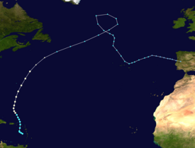
Though initially disorganized due to moderate wind shear, a subsequent decrease allowed for shower and thunderstorm activity to develop in earnest by October 14, 2012.
A cold front off the East Coast of the United States caused the system to turn northward and eventually northeastward by October 16, 2012, at which time Rafael attained its peak intensity with maximum sustained winds of 90 mph (150 km/h).
As the cyclone entered a more stable atmosphere and tracked across increasingly cooler sea surface temperatures, it began extratropical transition, a process the system completed by the following afternoon.
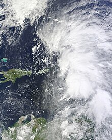
The wave remained disorganized until roughly midway between the Cape Verde Islands and Lesser Antilles, at which time a broad area of low pressure developed and convection began to consolidate around it.
[3] As the wave crossed into the eastern Caribbean Sea and slowed down, the previously broad and open surface low consolidated and became stacked with the mid-level center.
As it began to execute a turn towards the north under the influence of an upper-level trough to its west, a central dense overcast (CDO) was noted on satellite imagery.
An eye became visible on microwave imagery during the morning hours of October 16, during which time the cyclone attained its peak intensity as a Category 1 hurricane with maximum sustained winds of 90 mph (150 km/h) and a minimum barometric pressure of 969 mb (hPa; 28.61 inHg).
By the afternoon hours of that same day, data from an Air Force Reserve reconnaissance aircraft indicated that Rafael was on the verge of a weakening trend, attributed to decreasing sea surface temperatures and higher wind shear.
During this time, Rafael's extratropical remnant strengthened even further, with the storm's minimum central pressure bottoming out at 966 millibars (28.5 inHg) at 00:00 UTC on October 20.
The departments of public works and power authority placed emergency crews on standby, while all ports out of the U.S. Virgin Islands were open to outbound vessel traffic only; the Coast Guard advised mariners to prepare for impending severe weather.
[9] As a tropical storm, Rafael hit Guadeloupe with large amounts of rain, causing significant damage to homes and especially crops.
This watch was subsequently upgraded to a tropical storm warning the following morning, but was dropped by early on October 17 as the system passed northeast of the island.
[5] In advance of the system, residents were urged to take their typical precautionary measures;[15] in addition, the main two airlines on Bermuda—WestJet and United Airlines—cancelled hundreds of flights on October 16.
[19] Though tropical cyclone watches and warnings were not issued, city officials in St. John's recommended all residents in Newfoundland to prepare for Rafael.
Tropical storm (39–73 mph, 63–118 km/h)
Category 1 (74–95 mph, 119–153 km/h)
Category 2 (96–110 mph, 154–177 km/h)
Category 3 (111–129 mph, 178–208 km/h)
Category 4 (130–156 mph, 209–251 km/h)
Category 5 (≥157 mph, ≥252 km/h)
Unknown