Meteorological history of Typhoon Haiyan
Thereafter, it continued to intensify; at 12:00 UTC on November 7, the Japan Meteorological Agency (JMA) upgraded the storm's maximum ten-minute sustained winds to 230 km/h (64 m/s; 140 mph), the highest in relation to the cyclone.
At 1800 UTC, the JTWC estimated the system's one-minute sustained winds to 315 km/h (88 m/s; 196 mph), unofficially making Haiyan the fourth strongest tropical cyclone ever observed.
[5][6] Subsequent intensification resulted in the JMA upgrading the system to a tropical storm and assigning it the name Haiyan (Chinese: 海燕; lit.
[3] Meanwhile, the JTWC also upgraded it to a tropical storm, when the expansive system was steadily consolidating in an area of weak to moderate vertical wind shear and tracking westward along the southern periphery of a subtropical ridge.
[12][nb 3] That day, the Philippine Atmospheric, Geophysical and Astronomical Services Administration (PAGASA) assigned the storm the local name Yolanda as it approached their area of responsibility.
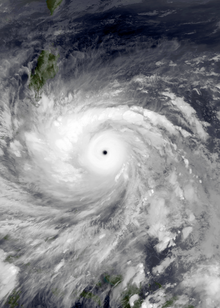
[17] Around 1200 UTC on November 7, Haiyan attained its peak intensity with ten-minute sustained winds of 230 km/h (64 m/s; 140 mph) and a barometric pressure of 895 mbar (hPa; 26.43 inHg).
[3] This made it the second-most intense tropical cyclone in the Northwest Pacific Ocean on record, based on wind speeds alone, along with Bess in 1982 and Megi in 2010, only after Tip in 1979.
[20] (It is important to note, however, that Patricia's winds were directly measured by hurricane hunters aircraft, observations which were not available for Haiyan, so the record is uncertain and comparing the intensities of the two storms is problematic.)
The storm displayed some characteristics of an annular tropical cyclone, though a strong convective band remained present along the western side of the system.
[22][23] This would have possibly made Haiyan the strongest tropical cyclone worldwide, however due to lack of hurricane hunters in the West Pacific, this is hard to verify, so Typhoon Tip of 1979 holds the record.
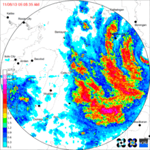
[20][25][27] As Haiyan approached Guiuan, mountainous terrain disrupted the cyclone's low-level inflow, slightly degrading the storm's structure, prompting slow weakening.
The Guiuan radar station failed shortly thereafter, with its radome blown into the Leyte Gulf, despite being designed to withstand the strongest typhoons.
[31] At 2315 UTC, a barometer at Tacloban Airport about 1.6 km (0.99 mi) south of the chasers measured a pressure of 955.6 mb (hPa; 28.22 inHg).
Based on the gradient between these positions, Dr. Jeff Masters of Weather Underground estimated that Haiyan may have had a central pressure of 888 mb (hPa; 26.2 inHg) when it struck Leyte.
[32] As Haiyan moved further into Leyte, it reached the Nacolod mountain range, whose 1500 meter peaks significantly disrupted the storm's low- and mid-level circulation.
The storm's core had been substantially disrupted during its passage through the Philippines, with only a partial eyewall remaining intact around a ragged cloud-filled eye.
[36] Environmental conditions ahead of the storm soon became less favorable, as cool stable air began wrapping into the western side of the circulation.
[39] Rapid weakening ensued as Haiyan approached its final landfall in Vietnam, with increasing wind shear displacing convection to the north of the center of circulation.