Timeline of the 2013 Pacific typhoon season
The scope of this article is the Pacific Ocean north of the equator, between 100°E and the International Date Line.
Tropical storms which form in the Western Pacific basin are assigned a name by the Japan Meteorological Agency (JMA).
Tropical depressions forming in this basin are given a number with a "W" suffix by the United States' Joint Typhoon Warning Center (JTWC).
PAGASA assigns local names to tropical depressions which form within its area of responsibility.
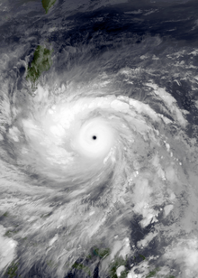
Typhoon Haiyan, the strongest storm of the season, formed on early November, before rapidly intensifying and making landfall in the Philippines with estimated 1-minute sustained wind speeds of up to 190mph (305kph), which made it the strongest storm to make landfall based on sustained wind speeds at that time.