Monsoon of South Asia
It affects the Indian subcontinent, where it is one of the oldest and most anticipated weather phenomena and an economically important pattern every year from June through September, but it is only partly understood and notoriously difficult to predict.
Several theories have been proposed to explain the origin, process, strength, variability, distribution, and general vagaries of the monsoon, but understanding and predictability are still evolving.
[6] Scientifically however, while generally defined as a system of winds characterized by a seasonal reversal of direction,[7] there are several more detailed definitions used by various meteorological and climatological sources.
[13] The onset of the monsoon occurs over the Bay of Bengal in May, arriving at the Indian Peninsula by June, and then the winds move towards the South China Sea.
[16] One of the most commonly used words to describe the erratic nature of the monsoon is "vagaries", used in newspapers,[17] magazines,[18] books,[19] web portals[20] to insurance plans,[21] and India's budget discussions.
In the recent past, rainfall variability in short time periods (about a week) were attributed to desert dust over the Arabian Sea and Western Asia.
[23] Normally, the southwest monsoon can be expected to "burst" onto the western coast of India (near Thiruvananthapuram) at the beginning of June and to cover the entire country by mid-July.
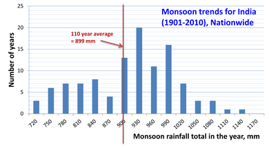
The exact criteria for a normal monsoon are defined by the India Meteorological Department with calculations for the mean and standard deviation of each of these variables.
It states that during the hot subtropical summers, the massive landmass of the Indian Peninsula heats up at a different rate than the surrounding seas, resulting in a pressure gradient from south to north.
Only part of the northeast monsoon passing over the Bay of Bengal picks up moisture, causing rain in Andhra Pradesh and Tamil Nadu during the winter months.
This criticism does not deny the role of differential heating of sea and land in generating monsoon winds, but casts it as one of several factors rather than the only one.
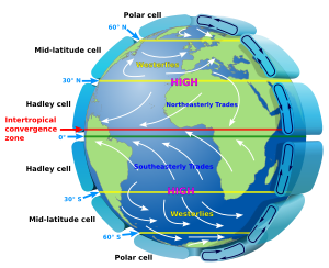
The prevailing winds of the atmospheric circulation arise because of the difference in pressure at various latitudes and act as means for distribution of thermal energy on the planet.
[Note 6] These pick up moisture while traveling from sea to land and cause orographic rain once they hit the highlands of the Indian Peninsula.
And when coupled with the traditional theory (based on the heating of sea and land), it enhances the explanation of the varying intensity of monsoon precipitation along the coastal regions with orographic barriers.
The high temperature during the summer over the Tibetan Plateau, as well as over Central Asia in general, is believed to be the critical factor leading to the formation of the tropical easterly jet over India.
According to this theory, during the summer months in the Northern Hemisphere, the ITCZ shifts north, pulling the southwest monsoon winds onto the land from the sea.
It is only when the Tibetan Plateau heats up significantly more than the Himalayas that the ITCZ rises abruptly and swiftly shifts north, leading to the bursting of monsoon rains over the Indian subcontinent.
The reverse shift takes place for the northeast monsoon winds, leading to a second, minor burst of rainfall over the eastern Indian Peninsula during the Northern Hemisphere winter months.
According to this theory, the onset of the southwest monsoon is driven by the shift of the subtropical westerly jet north from over the plains of India toward the Tibetan Plateau.
The warm surface water moving toward the coast of Peru with El Niño is pushed west by the trade winds, thereby raising the temperature of the southern Pacific Ocean.
Southern Oscillation, a phenomenon first observed by Sir Gilbert Walker, director general of observatories in India, refers to the seesaw relationship of atmospheric pressures between Tahiti and Darwin, Australia.
[29] As with ENSO, the atmospheric component of the IOD was later discovered and the cumulative phenomenon named Equatorial Indian Ocean oscillation (EQUINOO).
The reduction in the summer monsoon rainfall has grave consequences over central India because at least 60% of the agriculture in this region is still largely rain-fed.
[42] The Centre for Development of Advanced Computing (CDAC) at Bengaluru facilitated the Seasonal Prediction of Indian Monsoon (SPIM) experiment on the PARAM Padma supercomputing system.
[43] This project involved simulated runs of historical data from 1985 to 2004 to try to establish the relationship of five atmospheric general circulation models with monsoon rainfall distribution.
[44] However, following the 2009 drought in India (worst since 1972),[46] The department decided in 2010 that it needed to develop an "indigenous model"[47] to further improve its prediction capabilities.
Mawsynram and Cherrapunji, both in the Indian state of Meghalaya, alternate as the wettest places on Earth given the quantity of their rainfall,[48] though there are other cities with similar claims.
This has a cascading effect on the secondary economic sectors, the overall economy, food inflation, and therefore the general population's quality and cost of living.
[49] The down side however is that when monsoon rains are weak, crop production is low leading to higher food prices with limited supply.
[50] As a result, the Indian government is actively working with farmers and the nation's meteorological department to produce more drought resistant crops.