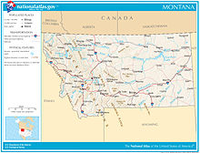
Montana
Montana has no official nickname but several unofficial ones, most notably "Big Sky Country", "The Treasure State", "Land of the Shining Mountains", and "The Last Best Place".
In 1855, Washington Territorial Governor Isaac Stevens negotiated the Hellgate Treaty between the United States government and the Salish, Pend d'Oreille, and Kootenai people of western Montana, which established boundaries for the tribal nations.
[29] In 1875, General Philip Sheridan pleaded to a joint session of Congress to authorize the slaughtering of bison herds to deprive Native people of their source of food.
Jay Cooke, the NPR president, launched major surveys into the Yellowstone valley in 1871, 1872, and 1873, which were challenged forcefully by the Sioux under chief Sitting Bull.
In 1909, Congress passed the Enlarged Homestead Act that expanded the amount of free land from 160 to 320 acres (0.6 to 1.3 km2) per family and in 1912 reduced the time to "prove up" on a claim to three years.
[48] The word honyocker possibly derived from the ethnic slur hunyak[53] and was applied in a derisive manner at homesteaders, who were perceived as being "greenhorns", "new at his business", or "unprepared".
He was the Joad of a [half] century ago, swarming into a hostile land: duped when he started, robbed when he arrived; hopeful, courageous, ambitious: he sought independence or adventure, comfort and security ...
U.S. Attorney Burton K. Wheeler and several district court judges who hesitated to prosecute or convict people brought up on charges were strongly criticized.
[71][72] By the time the U.S. entered World War II on December 8, 1941, many Montanans had enlisted in the military to escape the poor national economy of the previous decade.
[73][74] Air bases were built in Great Falls, Lewistown, Cut Bank, and Glasgow, some of which were used as staging areas to prepare planes to be sent to allied forces in the Soviet Union.
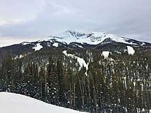
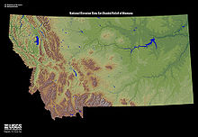
East and north of this transition zone are the expansive and sparsely populated Northern Plains, with tableland prairies, smaller island mountain ranges, and badlands.
[113] Surface soils in the area are highly diverse, and greatly affected by the local geology, whether glaciated plain, intermountain basin, mountain foothills, or tableland.
[114] Foothill regions are often covered in weathered stone or broken slate, or consist of uncovered bare rock (usually igneous, quartzite, sandstone, or shale).
[115] The soil of intermountain basins usually consists of clay, gravel, sand, silt, and volcanic ash, much of it laid down by lakes which covered the region during the Oligocene 33 to 23 million years ago.
[133] Nearly one-third of the Missouri River in Montana lies behind 10 dams: Toston, Canyon Ferry, Hauser, Holter, Black Eagle, Rainbow, Cochrane, Ryan, Morony, and Fort Peck.
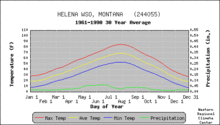
[168] Areas managed by the National Park Service include:[169] Montana is a large state with considerable variation in geography, topography and elevation, and the climate is equally varied.
The area west of the divide has a modified northern Pacific Coast climate, with milder winters, cooler summers, less wind, and a longer growing season.
[187] Collectively all of these areas (excluding Havre) are known informally as the "big seven", as they are consistently the seven largest communities in the state (their rank order in terms of population is Billings, Missoula, Great Falls, Bozeman, Butte, Helena and Kalispell, according to the 2010 U.S.
[204] Of Montana's 20 largest cities, Polson (15.7%), Havre (13.0%), Great Falls (5.0%), Billings (4.4%), and Anaconda (3.1%) had the greatest percentages of Native American residents in 2010.
[209] Today, the Missoula area has a large Hmong population[210] and the nearly 3,000 Montanans who claim Filipino ancestry are the largest Asian American group in the state.
[217] South Dakota passed similar legislation in 2007, and Wisconsin was working to strengthen its own program based on this model—and the current practices of Montana's schools.
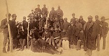
"[218] What is now Montana was at various times inhabited by tribes such as the Crow, the Blackfeet, the Assiniboine, the Gros Ventre, the Kootenai, the Flathead Salish and Kalispel, the Kiowa, the Sioux, the Arapaho, the Arikara, the Bannock, the Cheyenne, the Ojibwe, the Hidatsa, the Cree, the Nez Perce, the Mandan, the Shoshone and the Spokane.
[247] Significant industries exist for lumber and mineral extraction; the state's resources include gold, coal, silver, talc, and vermiculite.
Evelyn Cameron, a naturalist and photographer from Terry documented early 20th-century life on the Montana prairie, taking startlingly clear pictures of everything around her: cowboys, sheepherders, weddings, river crossings, freight wagons, people working, badlands, eagles, coyotes and wolves.
[263] James Willard Schultz ("Apikuni") from Browning is most noted for his prolific stories about Blackfeet life and his contributions to the naming of prominent features in Glacier National Park.
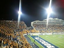
Baseball is the minor-league sport with the longest heritage in the state and Montana is home to four independent teams, all members of the Pioneer League: the Billings Mustangs, Great Falls Voyagers, Missoula PaddleHeads and the Glacier Range Riders.
[332] Major amendments include establishment of a reclamation trust (funded by taxes on natural resource extraction) to restore mined land (1974); restoration of sovereign immunity, when such immunity has been approved by a two-thirds vote in each house (1974); establishment of a 90-day biennial (rather than annual) legislative session (1974); establishment of a coal tax trust fund, funded by a tax on coal extraction (1976); conversion of the mandatory decennial review of county government into a voluntary one, to be approved or disallowed by residents in each county (1978); conversion of the provision of public assistance from a mandatory civil right to a non-fundamental legislative prerogative (1988);[333] a new constitutional right to hunt and fish (2004); a now-defunct prohibition on same-sex marriage (2004); a prohibition on new taxes on the sale or transfer of real property (2010), and a constitutional provision codifying abortion rights (2024).
There are 18 departments and offices which make up the executive branch: Administration; Agriculture; Auditor (securities and insurance); Commerce; Corrections; Environmental Quality; Fish, Wildlife & Parks; Justice; Labor and Industry; Livestock; Military Affairs; Natural Resources and Conservation; Public Health and Human Services; Revenue; State; and Transportation.
The Democratic Party's strength in the state is gained from support among unionized miners and railroad workers, while farmers generally vote Republican.
In the 2008 presidential election, Montana was considered a swing state and was ultimately won by Republican John McCain by a narrow margin of two percent.


-
Non-Hispanic White 50–60%60–70%70–80%80–90%90%+Native American 50–60%60–70%70–80%