Mount Aniakchak
Many lava domes and cones were emplaced within the caldera after the Aniakchak II eruption, with some events depositing ash over Alaska.
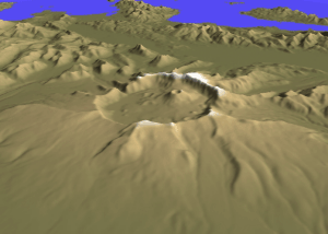
[6] The volcano is a 10 kilometers (6.2 mi) wide and 500–1,000 meters (1,600–3,300 ft) deep caldera,[7] formally named Aniakchak Crater.
[15] The Aleutian Volcanic Arc is part of the wider Pacific Ring of Fire[42] and began erupting during the Tertiary period.
[53] Phenocrysts are rare, they include amphibole, augite, clinopyroxene, hornblende, hypersthene, ilmenite, iron sulfide, magnetite, olivine, orthopyroxene, plagioclase and quartz, depending on the rock unit.
[52] Rather, mantle-derived basaltic melts, enriched by fluids produced during subduction, ascend into the crust[58] into a "mush"-like region above 15 kilometers (9.3 mi) depth at Aniakchak.
[60] Magmas differentiate within this mush region[61] at low pressures and high temperatures,[62] where fractional crystallization and melting of crustal rocks modify their chemistry.
[22] Two stages of early activity (850,000–550,000 and 440,000–10,000 years ago)[5] built a composite volcano formed by lava flows and rock fragments[2] produced by a central vent.
[99] Tephra layers on St. Michael Island imply that Aniakchak erupted 15,505 ± 312 years ago, but any evidence close to the volcano has been erased by erosion.
[36] The Aniakchak I eruption took place 9,500–7,500 years ago,[107] and emplaced volcanic bombs[99] and ignimbrites[2] on the volcano and in surrounding valleys.
[111][26] A tephra layer in Southeastern Alaska was attributed to an unidentified eruption of Aniakchak 5,300–5,030 years before present,[112] but may have originated at Mount Edgecumbe instead.
[113][114] Shortly before the Aniakchak II event, a smaller eruption may have emplaced a tephra layer in the Brooks Range of northern Alaska.
[115] Other large caldera-forming eruptions in Alaska took place at Mount Okmok, Fisher Caldera, and Veniaminof, with lesser events at Kaguyak and Black Peak.
[124] A more than 25 kilometers (16 mi) high eruption column rose over the volcano[125] and produced a lapilli and volcanic ash fallout.
[127] The column then collapsed,[110] and highly mobile[46] pyroclastic flows consisting of andesite and rhyodacite swept the volcano,[128] filling in valleys,[129] making turns[130] and moving upslope over topography.
[159] Areas close to the volcano remained uninhabited for more than two millennia,[105] and it is possible that the Brooks River Archeological District on the northern Alaska Peninsula became the destination of survivors.
[166] In Central Alaska, a decline in human activity 3,500 years ago may have been a consequence of volcanic eruptions like Aniakchak II and the "Jarvis Creek" event of Hayes volcano.
[168] There is evidence that peat accumulation at Cape Espenberg was interrupted by the eruption,[169] and vegetation growth was slow for up to a century at 1,100 kilometers (680 mi) from the volcano.
[174] A sulfur yield of 32 ± 11 teragrams has been reconstructed, making Aniakchak II one of the largest sulfur-producing volcanic eruptions of the late Holocene.
[182] About 1,860 years before present, it drained catastrophically through a notch in the northeastern rim, forming The Gates gorge,[46] in one of the largest known floods[j] (peak discharge of 1,100,000 cubic meters per second (39,000,000 cu ft/s)[188]) of the Holocene.
[189][190] The overflow was caused either by headward erosion of a river outside the caldera, capturing it, or a consequence of eruptions[191] that stirred the lake and formed waves[192] which overtopped its rim.
[28] It had a volcanic explosivity index of 3–4,[27] destroying Half Cone in a series of Plinian eruptions and emplacing the Cobweb lava flow.
[210] In 2024, the date 1600 was proposed, as well as a link to tephra and sulfate deposits in Greenland and climatic anomalies in that year (compounding these caused by Huaynaputina).
[218] Ash fell in various communities, including Chignik, Kanakanak, Katmai National Park, Kodiak Island, Nushagak Peninsula, Port Heiden,[m] and Holy Cross 600 kilometers (370 mi) north of the volcano.
[220] In June, the new vents were still emitting volcanic gases with a smell of sulfur, and Surprise Lake and Aniakchak River were discolored.
The eruption was initially magmatic, then became phreatomagmatic when decreasing magma ascent speed allowed water from the lakes in the caldera to flow into the vent.
[99] Satellite imagery has noted ongoing sinking of the caldera floor, with the rate (a few millimeters per year) decreasing over time.
[243] Aircraft flying into volcanic ash clouds can suffer engine failures,[244] and Aniakchak is located beneath one of the major air routes of the North Pacific.
Precipitating volcanic ash can smother plants and make roads slippery, irritate eyes and lungs, and damage machinery.
[248] While the hot springs and fumaroles are not a threat by themselves, in case of the ascent of new magma, temperatures and carbon dioxide concentrations may rise to dangerous levels.
[246] Aniakchak is monitored by the Alaska Volcano Observatory[46] since 1997[252] through seismometers and satellite images, and collects reports from visitors to the caldera and aircraft to detect renewed activity.