Mount Elbert
Mount Elbert is located in San Isabel National Forest, 12.1 miles (19.4 km) southwest (bearing 223°) of the city of Leadville in Lake County, Colorado.
Weather conditions often change rapidly, and afternoon thunderstorms are common in the summertime; hailstorms and snow are possible year-round.
For example, the base of Elbert on the eastern side exhibits expanses of igneous and metamorphic rocks exposed when the glaciers receded, leaving a lateral moraine.
[13] However, the summit ridge consists of metamorphic basement rock, which is Pre-Cambrian in origin and about 1.7 billion years old.
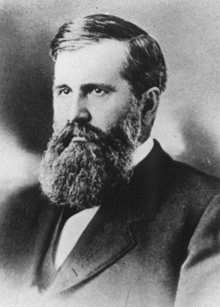
[13] Mount Elbert was named by miners in honor of Samuel Hitt Elbert, the governor of the then-Territory of Colorado, because he brokered a treaty in September 1873 with the Ute tribe that opened up more than 3,000,000 acres (12,000 km2) of reservation land to mining and railroad activity.
[7][16][15] A matter of some contention arose after the Great Depression over the heights of Elbert and its neighbor Mount Massive, which differ in elevation by only 12 feet (3.7 m).
[7] The first motorized ascent of Elbert occurred in 1949, when a Jeep was driven to the summit, apparently to judge suitability for skiing development.
pullata, Salix desertorum, Platanthera hyperborea, Thalictrum fendleri, Aquilegia canadensis, Chenopodium album, Gentiana detonsa var.
[18] Below treeline the mountain is heavily forested, with the lower slopes covered with a mixture of lodgepole pine, spruce, aspen, and fir.
[19] Some of the fauna reported on the climb to the summit include black bears, marmots, mule deer, pikas, and pocket gophers; there are also many species of birds.
The standard route ascends the peak from the east, starting from the Colorado Trail just north of Twin Lakes.
Although the most conventional form of ascent is by hiking, Anna Elizabeth Dickinson, the orator, ascended the mountain on a mule borrowed from the U.S.