San Luis Valley
It is an extensive high-elevation depositional basin of approximately 8,000 square miles (21,000 km2) with an average elevation of 7,664 feet (2,336 m) above sea level.
The San Luis Valley has a cold desert climate but has substantial water resources from the Rio Grande and groundwater.
Hispanic settlers began moving north and settling in the valley after the United States made a treaty with the Utes and established a fort in the early 1850s.
Early settlers built a church in the village that is now called San Luis and dedicated it on the Feast of Saint Louis, 21 June 1851.
[3] At present, the San Luis Valley has the largest native Hispanic population in Colorado; many families are directly descended from the original New Mexican settlers.
Irrigated agriculture is possible in the area due to groundwater and streams fed by the average 100 inches of snow the surrounding mountain ranges receive.
The principal towns are: Alamosa, Monte Vista, Del Norte, South Fork, Saguache, Center, Moffat, Fort Garland, San Luis, Blanca, Antonito, La Jara, Capulin, Manassa, Sanford, Romeo, Crestone, Villa Grove, Hooper, Mosca, San Acacio and a number of smaller locations.
A few other counties of Colorado have some land in the Rio Grande Basin including Archuleta, Mineral, Hinsdale, and San Juan.
Elevation rises as you go north in the valley to Poncha Pass, used now by U.S. Highway 285 and historically by the narrow gauge tracks of the Denver and Rio Grande Railroad.
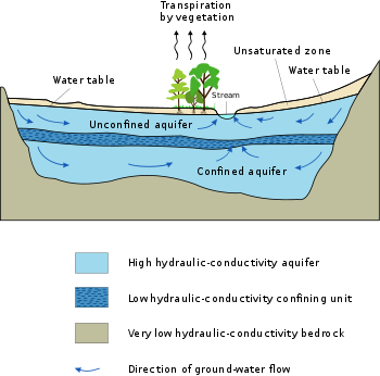
The relatively impermeable clay layers trap ground water in the "confined aquifer" which, if tapped, supplies artesian wells.
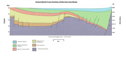
It is from those highlands to the west, in Paleozoic, Pennsylvanian, and Permian times that the coarse alluvial deposits of the Sangre de Cristo Formation such as the Crestone Conglomerate originated.
[16] In the middle and late Cretaceous Period, about 100 million years ago, the San Luis Valley lay on the shore of or beneath the Western Interior Seaway, a shallow sea which divided North America into two parts.
The Lexam oil play near Crestone is based on the hypothesis that there is oil trapped in Dakota Formation sandstones lying beneath Mancos Shale to the west of the Sangre de Cristo fault at the western base of the Sangre de Cristo Range southwest of Crestone.
This process over 30 million years resulted in an elevated and highly eroded peneplain where the San Luis Valley is today.
Sedimentary deposits formed in that basin during Eocene times remain in place beneath the western portion of the San Luis Valley.
In 1982, quinoa was successfully grown for the first time outside of South America in the San Luis Valley of Colorado,[19] and commercial growth has occurred since 1987.
[20] Less favored areas with a shorter growing season and less access to water rights tend to be devoted to alfalfa and grazing.
The valley is a flyway for many migrating birds including avocets, bald eagles, goldfinches, and a plethora of hawk species.
Agriculture in the San Luis Valley is enabled by irrigation, since average annual precipitation is just 7–10 inches (18–25 cm) whereas most ag crop production requires at least twice that much water.
Tourism has become a more important part of the economy in recent years, coupled with attempts to develop the area as a retirement destination.
The tallest dunes in North America are the centerpiece in a diverse landscape of grasslands, wetlands, forests, alpine lakes, and tundra.
Tourist attractions suggested by National Geographic Traveler include the Monte Vista Crane Festival in March,[23] Los Caminos Antiguos, a regional road network, the Luther Bean Museum at Adams State University.
To the northeast of Alamosa lie the San Luis Lakes State Wildlife Area, the San Luis Lakes and the Great Sand Dunes National Park[a] At Fort Garland, Colorado south of the Great Sand Dunes on U.S. Highway 160 the Fort Garland Museum is recommended and further south on State Highway 159 at San Luis, Colorado, the oldest town in Colorado, the bronze sculptures by Huberto Maestas, depicting the Stations of the Cross.
The arts of the San Luis Valley draw from traditions of the early Utes, Apaches, and Comanches and the later Spanish-speaking immigrants.
[32] There are also a number of utility-scale photovoltaic power stations in the valley, and an active market in selling or leasing land to be used for solar facilities.
On 11 December 2009, more than 125 people gathered to respond to a proposal by Tessera Solar (affiliated with Stirling Energy Systems) to install 8,000 parabolic mirrors, 40 feet each, on 1,500 acres (6.1 km2) near Saguache, Colorado.
[36] There has also been controversy regarding proposed transmission lines over both Poncha and La Veta passes, which would open the door to much more industrial solar development.
[37] In 2012, the United States Department of Interior designated several Solar Energy Zones on BLM lands in the valley, although no projects have yet been announced to be in development.
[38] A significant portion of the residents of the San Luis Valley are Hispanic with historic populations in Costilla and Conejos counties which were settled by early migrants from New Mexico.
[46] San Luis Valley Regional Medical Center is a full service Acute-Care hospital and specialty physician clinic.