Mount Fuji
[4][5] The mountain is located about 100 km (62 mi) southwest of Tokyo and is visible from the Japanese capital on clear days.
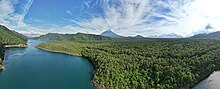
Mount Fuji's exceptionally symmetrical cone, which is covered in snow for about five months of the year, is commonly used as a cultural icon of Japan and is frequently depicted in art and photography, as well as visited by sightseers, hikers and mountain climbers.
[8] The current kanji for Mount Fuji, 富 and 士, mean "wealth" or "abundant" and "man of status" respectively.
A text of the 9th century, Tale of the Bamboo Cutter, says that the name came from "immortal" (不死, fushi, fuji) and also from the image of abundant (富, fu) soldiers (士, shi, ji)[note 1] ascending the slopes of the mountain.
Hirata Atsutane, a Japanese classical scholar in the Edo period, speculated that the name is from a word meaning "a mountain standing up shapely as an ear (穗, ho) of a rice plant".
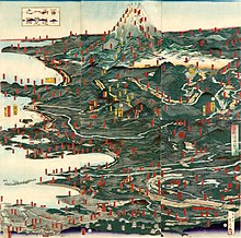
[15] Mount Fuji is an attractive volcanic cone and has been a frequent subject of Japanese art especially after 1600, when Edo (now Tokyo) became the capital and people saw the mountain while traveling on the Tōkaidō road.
According to the historian H. Byron Earhart, "in medieval times it eventually came to be seen by Japanese as the "number one" mountain of the known world of the three countries of India, China, and Japan".
All 113 passengers and 11 crew members died in the disaster, which was attributed to the extreme clear-air turbulence caused by lee waves downwind of the mountain.
[26][27] In the early 20th century, populist educator Frederick Starr's Chautauqua lectures about his several ascents of Mount Fuji— in 1913, 1919, and 1923—were widely known in America.
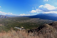
Four small cities surround it - Gotemba to the east, Fujiyoshida to the north, Fujinomiya to the southwest, and Fuji to the south - as well as several towns and villages in the area.
It can be seen more distantly from Yokohama, Tokyo, and sometimes as far as Chiba, Saitama, Tochigi, Ibaraki and Lake Hamana when the sky is clear.
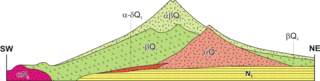
Sen-komitake was followed by the "Komitake Fuji", a basalt layer believed to be formed several hundred thousand years ago.
Ashitake Volcano was active from 400,000 to 100,000 years ago and is located 20 km (12 mi) southeast of Mount Fuji.
About 11,000 years ago, a large amount of lava began to erupt from the west side of the top of the ancient Fuji mountain.
In September 2012, mathematical models created by the National Research Institute for Earth Science and Disaster Prevention (NRIESDP) suggested that the pressure in Mount Fuji's magma chamber could be 1.6 megapascals higher than it was before its last eruption in 1707.
[58] However, since there is no known method of directly measuring the pressure of a volcano's magma chamber, indirect calculations of the type used by NRIESDP are speculative and unverifiable.
Other indicators suggestive of heightened eruptive danger, such as active fumaroles and recently discovered faults, are typical occurrences at this type of volcano.
In 2021, a new hazard map was created to help residents plan for evacuation, stoking fears because of its increased estimate of lava flow and additional vents.
[60] Soon afterwards, a 4.8 magnitude earthquake hit the area, sending the phrase "Mt Fuji eruption" trending on Twitter.
Folk tales and legends tell of ghosts, demons, yūrei and yōkai haunting the forest, and in the 19th century, Aokigahara was one of many places poor families abandoned the very young and elderly.
[66][67] Many hikers mark their routes by leaving colored plastic tape behind as they pass, raising concern among prefectural officials about the forest's ecosystem.
[70] The most popular period for people to hike up Mount Fuji is from July to August, while huts and other facilities are operating and the weather is warmest.
Paragliders take off in the vicinity of the fifth station Gotemba parking lot, between Subashiri and Hōei-zan peak on the south side of the mountain, in addition to several other locations, depending on wind direction.
On 1 February 2024, the Yamanashi prefectural government imposed a mandatory fee of 2,000 yen ($13) for hikers using the Yoshida trail beginning in the summer season as part of efforts to ease congestion and provide funding for safety protocols.
[76] It later announced that it would impose a daily limit of 4,000 hikers on the trail and close it between 4 p.m. and 3 a.m except for guests in mountain lodges.
[77] The Shizuoka prefectural government subsequently announced that it would also close the Subashiri, Gotemba and Fujinomiya trails at the same time period with the same exceptions, citing also concerns over congestion.
[78] In Shinto mythology, Kuninotokotachi (国之常立神?, Kuninotokotachi-no-Kami, in Kojiki)(国常立尊?, Kuninotokotachi-no-Mikoto, in Nihon Shoki) is one of the two gods born from "something like a reed that arose from the soil" when the earth was chaotic.
According to the Nihon Shoki, Konohanasakuya-hime, wife of Ninigi, is the goddess of Mount Fuji, where Fujisan Hongū Sengen Taisha is dedicated for her.
In the Heian period (794–1185), volcanic activity subsided and Fuji was used as a base for Shugendō, a syncretic religion combining mountain worship and Buddhism.
[80] As a national symbol of the country, the mountain has been depicted in various art media such as paintings, woodblock prints (such as Hokusai's Thirty-six Views of Mount Fuji and 100 Views of Mount Fuji from the 1830s), poetry, music, theater, film, manga, anime, pottery[81] and even Kawaii subculture.