Global Positioning System
[5] It does not require the user to transmit any data, and operates independently of any telephone or Internet reception, though these technologies can enhance the usefulness of the GPS positioning information.
[15] The GPS project was launched in the United States in 1973 to overcome the limitations of previous navigation systems,[16] combining ideas from several predecessors, including classified engineering design studies from the 1960s.
[17] The work of Gladys West on the creation of the mathematical geodetic Earth model is credited as instrumental in the development of computational techniques for detecting satellite positions with the precision needed for GPS.
In 1955, Friedwardt Winterberg proposed a test of general relativity—detecting time slowing in a strong gravitational field using accurate atomic clocks placed in orbit inside artificial satellites.
[20] When the Soviet Union launched its first artificial satellite (Sputnik 1) in 1957, two American physicists, William Guier and George Weiffenbach, at Johns Hopkins University's Applied Physics Laboratory (APL) monitored its radio transmissions.
Early the next year, Frank McClure, the deputy director of the APL, asked Guier and Weiffenbach to investigate the inverse problem: pinpointing the user's location, given the satellite's.
A team led by Harold L. Jury of Pan Am Aerospace Division in Florida from 1970 to 1973, used real-time data assimilation and recursive estimation to do so, reducing systematic and residual errors to a manageable level to permit accurate navigation.
[34] During Labor Day weekend in 1973, a meeting of about twelve military officers at the Pentagon discussed the creation of a Defense Navigation Satellite System (DNSS).
[40] After Korean Air Lines Flight 007, a Boeing 747 carrying 269 people, was shot down by a Soviet interceptor aircraft after straying in prohibited airspace because of navigational errors,[41] in the vicinity of Sakhalin and Moneron Islands, President Ronald Reagan issued a directive making GPS freely available for civilian use, once it was sufficiently developed, as a common good.
This changed on May 1, 2000, with U.S. President Bill Clinton signing a policy directive to turn off Selective Availability to provide the same accuracy to civilians that was afforded to the military.
The directive was proposed by the U.S. Secretary of Defense, William Perry, in view of the widespread growth of differential GPS services by private industry to improve civilian accuracy.
After that, the National Space-Based Positioning, Navigation and Timing Executive Committee was established by presidential directive in 2004 to advise and coordinate federal departments and agencies on matters concerning the GPS and related systems.
The U.S. Department of Defense is required by law to "maintain a Standard Positioning Service (as defined in the federal radio navigation plan and the standard positioning service signal specification) that will be available on a continuous, worldwide basis" and "develop measures to prevent hostile use of GPS and its augmentations without unduly disrupting or degrading civilian uses".
The IAF Honors and Awards Committee recognized the uniqueness of the GPS program and the exemplary role it has played in building international collaboration for the benefit of humanity.
[73] On December 6, 2018, Gladys West was inducted into the Air Force Space and Missile Pioneers Hall of Fame in recognition of her work on an extremely accurate geodetic Earth model, which was ultimately used to determine the orbit of the GPS constellation.
[a] Some GPS receivers may use additional clues or assumptions such as reusing the last known altitude, dead reckoning, inertial navigation, or including information from the vehicle computer, to give a (possibly degraded) position when fewer than four satellites are visible.
[107][108] In late 2023, Frank Calvelli, the assistant secretary of the Air Force for space acquisitions and integration, stated that the project was estimated to go live some time during the summer of 2024.
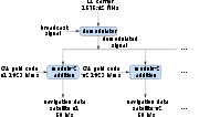
In general, GPS receivers are composed of an antenna, tuned to the frequencies transmitted by the satellites, receiver-processors, and a highly stable clock (often a crystal oscillator).
[citation needed] As of 2006[update], even low-cost units commonly include Wide Area Augmentation System (WAAS) receivers.
GPS's accurate time facilitates everyday activities such as banking, mobile phone operations, and even the control of power grids by allowing well synchronized hand-off switching.
All GPS receivers capable of functioning above 60,000 ft (18 km) above sea level and 1,000 kn (500 m/s; 2,000 km/h; 1,000 mph), or designed or modified for use with unmanned missiles and aircraft, are classified as munitions (weapons)—which means they require State Department export licenses.
Russia seems to have several objectives for this approach, such as intimidating neighbors while undermining confidence in their reliance on American systems, promoting their GLONASS alternative, disrupting Western military exercises, and protecting assets from drones.
[153][154] In the Russo-Ukrainian War, GPS-guided munitions provided to Ukraine by NATO countries experienced significant failure rates as a result of Russian electronic warfare.
This filing (SAT-MOD-20101118-00239) amounted to a request to run several orders of magnitude more power in the same frequency band for terrestrial base stations, essentially repurposing what was supposed to be a "quiet neighborhood" for signals from space as the equivalent of a cellular network.
This is done by multiplying the basic resolution of the receiver by quantities called the geometric dilution of position (GDOP) factors, calculated from the relative sky directions of the satellites used.
A case has been made that iterative methods, such as the Gauss–Newton algorithm approach for solving over-determined non-linear least squares problems, generally provide more accurate solutions.
Artificial errors may result from jamming devices and threaten ships and aircraft[196] or from intentional signal degradation through selective availability, which limited accuracy to ≈ 6–12 m (20–40 ft), but has been switched off since May 1, 2000.
On February 14, 2012, the FCC initiated proceedings to vacate LightSquared's Conditional Waiver Order based on the NTIA's conclusion that there was currently no practical way to mitigate potential GPS interference.
[208] In those 2003 rules, the FCC stated: "As a preliminary matter, terrestrial [Commercial Mobile Radio Service ('CMRS')] and MSS ATC are expected to have different prices, coverage, product acceptance and distribution; therefore, the two services appear, at best, to be imperfect substitutes for one another that would be operating in predominantly different market segments ... MSS ATC is unlikely to compete directly with terrestrial CMRS for the same customer base...".
[214] The problems could also affect the Federal Aviation Administration upgrade to the air traffic control system, United States Defense Department guidance, and local emergency services including 911.