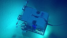
NOAAS Okeanos Explorer
From June to August 2010, an international team led by scientists from the United States and Indonesia collaborated to explore the depths of Indonesian waters.
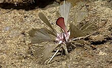
From June to July 2011, a team of scientists and technicians both at-sea and on shore conducted exploratory investigations on the diversity and distribution of deep-sea habitats and marine life in the vicinity of the Galápagos Islands.
When deployed from the ship with the Little Hercules, provided scientists and the audiences onshore with the very first video footage from a number of deepwater areas around the Galápagos.
In August 2011, NOAA Ship Okeanos Explorer embarked on an expedition to the deepest part of the Caribbean Sea, where a team of international scientists both at-sea and on shore conducted interdisciplinary investigations of the Mid-Cayman Rise – an ultra-slow spreading center where two plates gradually move apart and upwelling magma creates new crust – and the adjacent Cayman Trough.
After departing its homeport of Davisville, Rhode Island, on February 14, Okeanos Explorer proceeded offshore to Veatch Canyon where a sonar patch test was conducted to ensure the proper calibration of the vessel's multibeam echosounder.
As part of successful patch test operations, approximately 280 square kilometers of Veatch Canyon were bathymetrically mapped, including the majority of the first priority area identified by NEFSC.
Later in the cruise, focused survey operations conducted at Block, Ryan, and McMaster Canyons mapped approximately 900 square kilometers of seafloor, including 65 percent of the second NEFSC priority area.
Finally, focused mapping operations at Hendrickson, Toms, and Berkeley Canyons covered approximately 1400 square kilometers of seafloor, including 85 percent of the third NEFSC priority area.
Additionally, approximately 50 high school students, educators, and local media toured the vessel and learned about its mission at the conclusion of the expedition, in Charleston, South Carolina.
From March to April 2012, a team of scientists and technicians both at-sea and on shore conducted exploratory investigations on the diversity and distribution of deep-sea habitats and marine life in the northern Gulf of Mexico.
When these systems were deployed from the ship, we were able to provide scientists and the audiences onshore with real-time video footage from deepwater areas in important, yet largely unknown, U.S. waters.
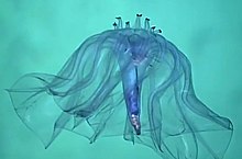
From July to August 2013, a team of scientists and technicians both at-sea and on shore will conduct exploratory investigations on the diversity and distribution of deep-sea habitats and marine life along the Northeast U.S. Canyons and at Mytilus Seamount, located within the U.S.
In the coming weeks, we expect to explore cold seeps, deep coral communities, undersea canyons, landslide features, and a seamount.
When these systems are deployed from the ship, we will be able to provide scientists and the audiences onshore with real-time video footage from deepwater areas in important, yet largely unknown, U.S. waters.
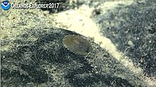
From February 25 to March 18, scientists will continue 2015 Hohonu Moana expedition efforts to explore deep-water habitats in and around Papahānaumokuākea Marine National Monument.
Along with biological specimens, 30 rock samples for age dating and geochemical analysis were collected to help reveal the geologic history of American Samoa seamounts, atolls, and islands.
[8] The first leg of this expedition took place from May 22 to June 6 and involved the collection of seafloor and water column mapping data to further improve fundamental understanding in this region and to facilitate remotely operated vehicle (ROV) dive planning.
During the mission, the team mapped over 4,900 linear kilometers, resulting in complete seafloor bathymetric coverage of over 16,000 square kilometers- an area larger than the states of Connecticut and Rhode Island combined, or nearly the size of Lake Ontario.
Prior to the first leg of the expedition, there was limited high-resolution multibeam mapping in the deepwater areas offshore the southeastern U.S. Live feeds of the dives could be viewed online in real time.
During the mapping operations NOAA Ocean Exploration partnered with the Defense POW/MIA Accounting Agency to deploy a small human portable Iver3 UUV and Deep Trekker Pivot RoV with the intent to locate a World War II-era B-25 bomber that was lost in 1944 with nine crew members aboard.
Over the course of the expedition the crew of Okeanos Explorer conducted 6 full RoV dives, mapped nearly 16,000 square kilometers, and collected a wide variety of biological and geological samples to help establish a baseline assessment of the Aleutian benthic habitat.