New York State Route 308
The highway passes near the Dutchess County Fairgrounds, several historical landmarks, and briefly parallels the Landsman Kill.
NY 308 was designated as part of the 1930 renumbering of New York state highways, incorporating a portion of the former Ulster and Delaware Turnpike.
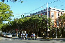
[7] The highway proceeds eastward on East Market Street for its first half-mile (800 m), passing at first two blocks of stores, then Rhinebeck's village and town halls, followed by residences.
[8] After passing Wynkoop Lane on the north NY 308 leaves the village and enters the Town of Rhinebeck; the surrounding area becomes more rural, with more woodlots and fields.
[9][10] Several small lakes surround NY 308 as it intersects CR 52, Salisbury Turnpike, in the hamlet of Eighmyville, 1.1 miles (1.8 km) east of Route 9G, and subsequently turns northeast again for the next two miles (3.2 km), crossing a large area of open fields in a level area, passing between two large hills of at least 400 feet (120 m).
[8] The elevation at the east terminus is 330 feet (100 m)[12] As indicated by artifacts recovered close to the road in Milan and in other areas along the Hudson River, the earliest inhabitants of the northern Dutchess County region were the Mohicans, a Native American nation, about 3,000 years ago.
[13] The range of the Mohicans extended from northern Dutchess County to the southern tip of Lake Champlain, and from the Catskill Mountains to the Berkshires in Massachusetts.
A bronze plaque attached to a large boulder was erected in November 1922 by Chancellor Livingston Chapter of the Daughters of the American Revolution on the property of the Beekman Arms, that marked the crossing of the Kings Highway (present-day US 9) and the Ulster and Salisbury Turnpike.
[21] Still existent, it reads "This stone marks the crossing of the Kings Highway and the Sepasco Indian Trail, later named the Ulster and Salisbury Turnpike, over which traveled the Connecticut Pioneers to their new homes in western New York.
The bridge, then partially complete, opened to traffic on February 2, 1957, at which time the ferry service between Kingston and Rhinecliff was terminated.