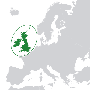
Terminology of the British Isles
On Great Britain are located the bulk of three constituent countries of the United Kingdom: Scotland in the north, England in the south and east and Wales in the west.
There are also numerous smaller islands off its coast (not coloured red on the attached map) that are administered as part of England, Scotland and Wales.
Although the Channel Islands are associated with the United Kingdom politically as Crown Dependencies, they are geographically an outcrop of the nearby French mainland (specifically, the Armorican massif), and historically they are the last remaining parts of the Duchy of Normandy, a title belonging to the British monarch.
This view may be supported by the existence of devolved governments with different levels of power in Scotland, Northern Ireland and Wales (see Asymmetrical federalism).
Thus the naming conventions tend towards describing distinct regions or nations which exist within a single sovereign state.
The Irish Free State became an autonomous dominion of the British Empire in 1922 when it seceded from the United Kingdom through the Anglo-Irish Treaty.
Crown dependency citizens who have no family ties to the United Kingdom were granted a special limited 'Islander Status' under EU law (article 6 of Protocol 3 in the Treaty of Accession of the UK to the European Community).
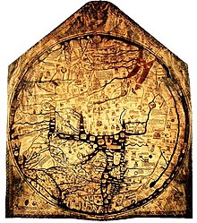
Parts of the Massaliote Periplus, a merchants' handbook describing searoutes of the sixth century BC, were used in translation in the writings of Avienius around AD 400.
[27] Several sources from around 150 BC to AD 70 include fragments of the travel writings of the ancient Greek Pytheas around 320 BC, use the terms Albion and Ierne[28][29] and have been described as referring to the British Isles, including Ireland, as the Prettanic or Brettanic Islands (Βρεττανικαὶ νῆσοι) or as αἱ Βρεττανιαι, literally "the Britains".
[27][29][30] Greek writers called the peoples of these islands the Πρεττανοί, later Bρεττανοί (alternative spellings of this and of all relative words have a single tau or a double nu), a name that possibly corresponds to the Priteni.
The Romans called the inhabitants of Gaul (modern France) Galli or Celtae, the latter term deriving from the Greek name Κελτοί for a central European people.
Nevertheless, Roman administration later incorporated the province of Britannia into the praetorian prefecture of Gaul, in common with Hispania, which had Celtiberians.
He writes of Great Britain: Albion ipsi nomen fuit, cum Britanniae vocarentur omnes de quibus mox paulo dicemus.
In his Geography written in the mid 2nd century and probably describing the position around AD 100,[30] Ptolemy includes both Great Britain (Albion) and Ireland (Iwernia) in the so called Bretanic island group.
[33] The name Albion for Great Britain fell from favour, and the island was described in Greek as Πρεττανία or Βρεττανία, in Latin Britannia, an inhabitant as Βρεττανός, Britannus, with the adjective Βρεττανικός, Britannicus, equating to "British".
With the visit of Hadrian in AD 121 coins introduced a female figure with the label BRITANNIA as a personification or goddess of the place.
It was written in the late seventh century by Adomnán of Iona, an Irish monk living on the Inner Hebridean island.
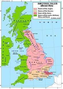
[35] Brythonic, Saxon and Viking kingdoms such as Strathclyde, Wessex, and Jórvík amalgamated, leading to the formation of Scotland, and England.
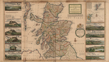
Abraham Ortelius makes clear his understanding that England, Scotland and Ireland were politically separate in 1570 by the full title of his map: Angliae, Scotiae et Hiberniae, sive Britannicar.
Some maps from this period also appear to mark Wales, and sometimes Cornwall, as separate areas within Britain, while the history of England created by Polydore Vergil[36] for Henry VIII states, "The whole country of Britain is divided into four parts, whereof the one is inhabited by Englishmen, the other of Scots, the third Welshmen and the fourth of Cornish people.
The majority Protestant northeast continued to be part of what became the United Kingdom of Great Britain and Northern Ireland.
Note that the geographical term Irish Sea thus far appears to have escaped political connotations, even though territorial control of the waters of the Irish Sea is divided between both the Republic of Ireland and the UK, and also includes a British Crown dependency, the Isle of Man—as yet there appears to be no controversy with the term’s usage to mirror that of "British Isles".
Some dictionary definitions[43][44] state that the British Isles is that it is a geographical term that refers to the whole of Ireland and Great Britain as well as the surrounding islands.
[45] The BBC[46] and The Times[citation needed] have style guides that mandate the dictionary definition but occasional misuse can be found on their websites.
[66] For a long time it was common for fans of the England football team to wave the British Union Jack; the use of the specifically English St George's Cross flag only gained popularity at the UEFA Euro 1996 tournament.
In classical times, the Graeco-Roman geographer Ptolemy in his Almagest also called the larger island megale Brettania (great Britain).
Many within the unionist community[69] and much of the press refer to Northern Ireland as Ulster – whereas the nationalist community refer to the traditional Irish province of Ulster, which is a nine-county entity that incorporates the three counties of Donegal, Cavan and Monaghan (which are in the Republic) along with the counties of Armagh, Antrim, Down, Fermanagh, Londonderry and Tyrone in Northern Ireland.
[70] The English names Albion and Albany are related to Alba and used poetically for either England or Scotland, or the whole island of Great Britain.
[71] Earlier dictionaries[72] give Oileáin Iarthair Eorpa as the translation, literally meaning West European Isles.
Today the most common term Éire agus an Bhreatain Mhór is used, meaning, literally, Ireland and Great Britain, as provided by terminological dictionaries.

Geographical feature Legal distinction