Geography of the United Kingdom
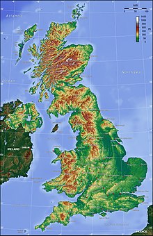
[4] England is the largest country of the United Kingdom, at 130,462 square kilometres (50,372 sq mi) accounting for just over half the total area of the UK.
The lowland areas are typically traversed by ranges of low hills, frequently composed of chalk, and flat plains.
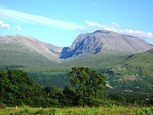
Scotland is the most mountainous country in the UK and its physical geography is distinguished by the Highland Boundary Fault which traverses the Scottish mainland from Helensburgh to Stonehaven.
Northern Ireland consists of mostly hilly landscape and its geography includes the Mourne Mountains as well as Lough Neagh, at 388 square kilometres (150 sq mi), the largest body of water in the UK.
[13] The overall geomorphology of the UK was shaped by a combination of forces including tectonics and climate change, in particular glaciation in northern and western areas.
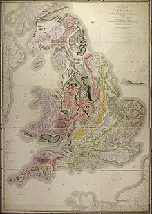
The geology of the UK is complex and diverse, a result of it being subject to a variety of plate tectonic processes over a very extended period of time.
The collision between continents continued during the Devonian period, producing uplift and subsequent erosion, resulting in the deposition of numerous sedimentary rock layers in lowlands and seas.
Around 360 Ma Great Britain was lying at the equator, covered by the warm shallow waters of the Rheic Ocean, during which time the Carboniferous Limestone was deposited, as found in the Mendip Hills and the Peak District of Derbyshire.
Around 280 Ma the Variscan orogeny mountain-building period occurred, again due to collision of continental plates, causing major deformation in south-west England.
Towards the end of this period granite was formed beneath the overlying rocks of Devon and Cornwall, now exposed at Dartmoor and Bodmin Moor.
Britain was located in the interior of Pangea where it was subject to a hot arid desert climate with frequent flash floods leaving deposits that formed beds of red sedimentary rock.
The remnants of the Variscan uplands in France to the south were eroded down, resulting in layers of the New Red Sandstone being deposited across central England.
The burial of algae and bacteria below the mud of the seafloor during this time resulted in the formation of North Sea oil and natural gas.
The modern continents having formed, the Cretaceous saw the formation of the Atlantic Ocean, gradually separating northern Scotland from North America.
Chalk and flints were deposited over much of Great Britain, now notably exposed at the White Cliffs of Dover and the Seven Sisters, and also forming Salisbury Plain.
The major eruptions at this time produced the Antrim Plateau, the basaltic columns of the Giant's Causeway and Lundy Island in the Bristol Channel.
During the most recent Devensian glaciation, which ended a mere 10,000 years ago, the icesheet reached south to Wolverhampton and Cardiff.
Amongst the most significant geological features created during the last twelve thousand years are the peat deposits of Scotland, and of coastal and upland areas of England and Wales.
[16] In total, it is estimated that the UK is made up of over one thousand small islands, the majority located off the north and west coasts of Scotland.
Due to the warming influence of the Gulf Stream, the UK is significantly warmer than some other locations at a similar latitude, such as Newfoundland.
The county of Essex is one of the driest in the UK, with an average annual rainfall of around 600 mm (23.6 in), although it typically rains on over 100 days per year.
The devolved governments and legislatures can make laws in a number of areas, such as culture, education The Scottish Parliament has been described as "one of the most powerful devolved parliaments in the world",[22] and can legislate for Scotland in areas in which the Northern Ireland Assembly or Welsh Parliament cannot for their respective countries, such as in areas as the distribution of money from dormant bank accounts, policing, criminal investigations and private security, anti-social behaviour and public order, air gun licensing, consumer advocacy and advice, Pubs Code Regulations, Sunday trading, heating and cooling, policing of railways and railway property, public sector compensation, the Crown Estate, registration of births, deaths and places of worship, Registration of land, agricultural charges and debentures, bank holidays and marriage, family relationships, matters concerning children.
The economic geography of the UK reflects not only its current position in the global economy, but its long history both as a trading nation and an imperial power.
The UK led the Industrial Revolution and its highly urban character is a legacy of this, with all its major cities being current or former centres of various forms of manufacturing.
A map of the major UK cities gives a good picture of where this activity occurred, in particular Belfast, Birmingham, Glasgow, Liverpool, London, Manchester, Newcastle and Sheffield.
[25] More recently, high technology firms have concentrated largely along the M4 motorway, partly because of access to Heathrow Airport, but also because of agglomeration economies.
Now, the UK financial industry is concentrated overwhelmingly in the City of London and Canary Wharf, with back office and administrative operations often dispersed around the south of England.
The effect of changing economic fortune has contributed to the creation of the so-called North-South divide, in which decaying industrial and ex-industrial areas of Northern England, Scotland and Wales contrast with the wealthy, finance and technology-led southern economy.
However, this is not to say that the north–south divide is uniform; some of the worst pockets of deprivation can be found in London, whilst parts of Cheshire and North Yorkshire are very wealthy.
[26] The high population density (especially in the southeast of England) coupled with a changing climate, is likely to put extreme pressure on the United Kingdom's water resources in the future.