Neighborhoods in Columbus, Ohio
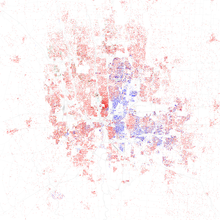
Native-born whites and assimilated ethnic Europeans are dispersed throughout the city, with higher concentrations in neighborhoods in the western half of Columbus, and areas immediately south and north of Downtown.
The city installed 17 lighted metal archways extending across High Street throughout the Short North, reminiscent of such arches present in the area in the early 1900s.
It is now the site of recreational facilities, gardens and an amphitheater, which hosts free live performances of Shakespearean plays during the summer months courtesy of the Actor's Theatre.
Since 2008, more than 70 properties have been improved through the hospital's Healthy Homes program and continued revitalization is happening along the major streets of Livingston and Parsons as the city moves to reconnect the downtown to its surrounding neighborhoods.
The neighborhood has become the focus of the city's revitalization efforts which include renovation of the historic Lincoln Theatre, construction of new condos and expansion of retail space along Mt.
A large advertisement with a hand-drawn map appeared in the Sunday, June 26, 1904, Columbus Dispatch newspaper touting the benefits of the Woodland Park Addition.
It says, "We give you paved streets, cement sidewalks, water, gas, sewerage, electric lights, plenty of fine forest trees and one of the best school districts in the city.
Per the old City of Columbus boundary: Overbrook Ravine to the north, Big Four railroad tracks to the east, Orchard Lane and roughly Oakland Park Avenue to the south, and the Olentangy River to the west.
Houses in this portion of Clintonville were built as higher end properties, lack alleyways and contain driveways as a nod to the increasing importance to the role of the automobile.
Developments and subdivisions located in this area are: Indian Springs, Northridge, Dominion Park, Northmoor, Brevoort Place, North Broadway Street and Woodland Crest.
The area near Westgate is home to the Hilltop branch of the Columbus Metropolitan Library, West High School, and Camp Chase Confederate Cemetery.
[citation needed] The community was developed to have all the essentials such as a shopping center, schools, and parks, and to incorporate safety considerations such as not positioning the homes on street corners to eliminate blind intersections.
In the 19th century, it was considered the center of the Irish-American community in the city after the arrival of immigrants fleeing the Great Famine, and Naughten Street, now Nationwide Boulevard, was nicknamed the "Irish Broadway."
Though most of the locally owned businesses in the neighborhood have been demolished to make way for widening roads and commercial development, the remaining houses in San Margherita still retain their original character.
Most of the simple homes sit on an acre (4,000 m2) of land, giving it a somewhat rural feeling, and backyard vineyards planted by the original residents are still maintained today.
Just south of Harrison West, the similar "Flytown" was destroyed during "slum clearance" in the 1960s and replaced by Interstate 670 and the "James Thurber Village" apartment and business area.
Redevelopment and gentrification spreading from Victorian Village closer to downtown has transformed the area in the last two decades, accelerating with the demolition of industrial sites along the Olentangy River.
The Battelle Memorial Institute, a major employer, at one time owned numerous rental properties and, concerned about urban blight on its doorstep, became actively involved in area redevelopment in the 1980s.
The housing in Dennison Place remains mostly a mixture of Victorian-style construction from the late 1800s, including Queen Anne, Italianate and Grand Victorian homes.
Of Parkview Drive and its surroundings, a 1909 Ohio State publication described the new north side park as a place of beauty where large oak and elm trees shaded a wading pond, five small lakes connected by a single stream, rustic benches, foot bridges and springs lined with cobblestones.
The rail spur connected to a factory for the production of ceramic and stone sewer pipes which stood on the present-day site of Dominion Middle School.
Because of this solid land bridge, the street could not be completed along the remaining length of the ravine to High Street like the other ravine basin roads without undertaking the massive expense and disruption of closing the rail spur to remove all of the landfill and reconstruct the rail spur as a proper spanning bridge, and instead had to curve back to meet Arcadia Avenue at the eastern edge of the factory grounds (today's Dominion Middle School grounds).
The landfill bridge that carried the rail spur was not removed and today exists as a footbridge connecting to the back grounds of a religious school on the north rim of the Ravine.
Sometime before 1953, likely due to worsening erosion as the loose cliff face naturally receded, the section of Parkview Drive from the Indianola Avenue underpass to the endpoint at Calumet Street was permanently closed and completely abandoned.
In 1975, on the recommendation of a watercourse planning report, the remaining segment of Parkview Drive connecting between 4th Street and the Indianola Avenue underpass was permanently closed and converted into the main trail for the park lining the ravine.
Today, this spur route, some of the easternmost dirt trails along the north side of the ravine, the Bird Tunnel, and the main path through Glen Echo Park are all that remains of Parkview Drive.
The need to avoid passing through this neighborhood along with conflicting local streetcar traffic south of Arcadia Avenue on High Street led to the need to route an interurban streetcar route via a series of turns that shifted traffic first to Indianola Avenue and then to Summit Street on their way to the interurban terminal at the present site of the Columbus Commons.
It is referred to as being part of the larger East-of-High off-campus residential district of the Ohio State University as it sits east of the Main Academic Campus of OSU.
Forming a triangular-shaped area on the southeast side, the Glenbrook neighborhood is bordered by Interstate 70 on the north, Courtright Road on the east, and U.S. Route 33 on the south and west.
Currently there are two properties not owned by CMH, Wonderland Community Church and Atlas Construction Co Inc. Wood-Brown is a historic ghost neighborhood of Columbus, Ohio.