New Jersey Route 133
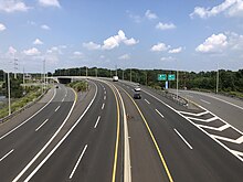
Route 133 (also known as the Hightstown Bypass) is a 4.06-mile-long (6.53 km) freeway located entirely in East Windsor, Mercer County, New Jersey, in the United States.
Heading eastbound, the on-ramp to Route 133 from One Mile Road merges in,[1] and the highway continues, passing to the north of homes and commercial buildings through East Windsor.
[1] The highway crosses the right-of-way of the historic Camden and Amboy Railroad; there is no bridge over the trackbed that is abandoned only a short few feet to the north and a few miles south around the Hightstown area.
Leaving the condos behind, the highway turns southward through lands and runs parallel to the south of Cranbury Station Road.
[2] The original concept for a bypass of Hightstown dates back to 1929, when local members of community requested a solution to relieve traffic on current-day CR 571 away from the downtown.
[3] In 1950, Governor Alfred E. Driscoll promoted the statewide expressway, citing that "it is unwise to expect city streets to bear the brunt of through, truck and passenger traffic.
[5] During the 1950s, the New Jersey State Highway Department released plans to construct the Princeton–Hightstown Bypass, a 14-mile-long (23 km), four-lane freeway connecting US 206 in the Montgomery Township community of Skillman to Route 33 in East Windsor.
[6][7] Although plans for Route 92 remained, the Somerset Freeway proposal was decommissioned in 1982, leaving open funds for use on other projects.
[8] After Route 92 was shifted northward by the New Jersey Department of Transportation (NJDOT) due to the belief that it would better serve residents further north, the proposal went into shadows.
[11] On November 30, 1999, the roadway, which was completed, was opened to commuter traffic,[12] over a year later than originally estimated (July 1998).
[11] Part of this delay was due to passage of Hurricane Floyd over the region during September 1999, whose heavy rains resulted in substantial erosion at the project site.
[13] At the time of the opening, the freeway carried a 45-mile-per-hour (72 km/h) speed limit; this was increased to 50 miles per hour (80 km/h) in August 2001.
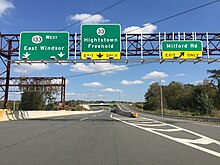
This new exit 8 would grant direct access to the bypass (without going through any traffic lights), as well as to Route 33, using grade-separated interchanges.
A leaf would be built from the turnpike ramp approaching the exit 8 toll gate, which would connect to Milford Road.