Newland, Kingston upon Hull
Before the mid 18th century Newland was a hamlet in a partially swampy agricultural area, located near the crossroads of Cottingham and Beverley-Hull turnpikes.
The modern area of Newland includes and the former site of the Kingston upon Hull Municipal Training College (est.
[map 1] Near the Beverley Road crossroads is the original parish church, St John's; and to the west are some houses dating from the 19th century village.
[1] To the west is further housing within Hull, centred around Bricknell Avenue; at the western edge to the North and Northwest is the North Hull Estate, and beyond that Cottingham and the Orchard Park Estate; to the south-west and south-east are the urban areas of The Avenues, Pearson Park, and Stepney.
[2][3] The area (excluding Clough Road) is predominately a mixture of housing and educational buildings, with significant open spaces including playing fields, allotments, and the Northern Cemetery.
The NW-SW route of the now covered Cottingham Drain is still visible from the mapped or aerial geography, and forms a boundary between the University (excluding former Humberside polytechnic buildings) and The Quadrant area of the North Hull Estate.
[note 1] In 1764 the act was extended in duration, with the road from Newland Bridge to Cottingham added to the trustees' responsibilities.
The two rooms are connected by the main hallway which has the decorations of ornate dark oak wooden panelling and elaborate coffered ceiling]].
The house, standing in its own "well timbered and secluded gardens of about 1 acre of land"[9] are well protected with high brick walls established trees and shrubs which include a tennis, croquet and bowls lawn.
The house, which is listed under section 32 of the Town and Country Planning Act 1932 as of Historic or Architectural interest and is probably unique within the Hull City boundary.
[10] The Barmston Drain crossed Beverley Road east of the village running very approximately parallel with, and around 0.5 miles (1 km) west of, the River Hull.
[14][map 4] The church, St John's (built 1833) is in the perpendicular style in yellow brick with ashlar dressings and a slate roof.
[11][21] Some clay extraction took place in Newland – with a pit to the north of the village, and a substantial brick and tile works nearer the River Hull.
[24] A Wesleyan chapel, designed by William Botterill in a gothic style was opened on Cottingham Road in Newland in 1858 (enlarged 1867, 1873, later used by the Port of Hull Society, dem.
[29][map 6] The Newland Park Estate was established c. 1877 by William Botterill on the south side of Cottingham Road.
[map 7] It developed slowly as a high status middle class housing estate over the next half century.
[25] Additionally another brick and tile works had been established between Igglemire Lane,[note 2] and the Beverley and Barmston Drain,[21][32] as well as one west of Newland Avenue, south of Sharp Street.
[32][note 9][map 9] At the far south end of the Newland Avenue area a number of civic buildings were put up around the end of the 19th century: the George Lamb Memorial Chapel was built 1893 on Lambert Street in a Classical Revival style for the Primitive Methodists;[38][28][25][map 10] the Anglican St Augustine of Hippo church (1896, dem.1976), and its associated church hall (1902), and vicarage (No.41 Queen's Road, 1899/1900).
[17][map 14] At the end of the 19th century (1895–1898), a large group of "Sailor's Orphan Cottage Homes", more recently known as "Newland Homes", were built in yellow brick on the north side of Cottingham Road by the Port of Hull Society,[map 15] with several local businessmen contributing funds for their construction, including Joseph Rank, Francis Reckitt, Sir James Reckitt, as well as benefactors from outside Hull including William Richardson, G Buckston Browne and Sir Titus Salt, and contributions from the towns of Whitby and Hartlepool.
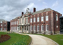
[map 20] Buildings included a library, halls of residence, and offices were built (1909–13) in three blocks surrounding an oval of ground facing Cottingham Road, together with lodges on either side, with a gymnasium to the rear.
[56][57] The (current) Haworth Arms at the Beverley Road/Cottingham Road junction was built in 1925 in a brick and timber framed style.
[58] An octagonal brick Methodist church was added at the Cottingham Road end of Newland Avenue in 1928, designed by Alfred Gelder.
[59] At the southern extremity of the Newland Avenue area a Roman Catholic church, dedicated to St Vincent de Paul was built in 1932 in a Romanesque style in brick.
[17][64][map 27] Further west much of the Newland Park Estate had now been developed, a new estate established on the north side of the Cottingham Road around Cranbrook Avenue, and Chanterlands Avenue North laid out along the route of Far Salt Ings Lane, giving access to the new cemetery.
[66] During the Second World War an anti-aircraft battery was on the Chanterlands Avenue side of the Northern Cemetery;[67] there was also a military camp at the junction of Beverley Road and Endike Lane (later a TA barracks);[68] other military installations included barrage balloons, anti-glider trenches and other associated military structures around the Oak Road playing field area in the north of Newland;[69] as well as numerous structures built for more general use, specifically emergency water supply tanks, and numerous civilian air raid shelters.
[17][map 29] By the beginning of the 1950s housing development in the Newland area had reached a level that was mostly maintained until the end of the 20th century – overall development consisted of around half housing, the remainder open spaces including allotments, the Northern cemetery, and playing fields, with a large amount of space taken up by the municipal college and university college, as well as other educational establishments – the colleges would expand significantly into some of the open space over the latter part of the 20th century.
Notable additions include the Middleton Hall and (now) Larkin Building (1965–67); and the Gulbenkian Centre (1967–69); both listed structures.
[56][57] The municipal college was also expanded in the post war period – with four new blocks added to the rear (1959–63), plus a dodecagonal timber faced structure, the Loxley building, (c. 1960).
[88][note 15] At St Mary's a 6,725 square metres (72,390 sq ft) three-storey replacement main school building was to be built to the front the site of a previous school front buildings, and a 1,046 square metres (11,260 sq ft) two-storey sports facilities added.
[72][95][map 30] In 2014 Hull University gained planning permission to build multistorey accommodation blocks on former playing fields on the north side of its Newland campus.