2001 Nisqually earthquake
The epicenter was in the southern Puget Sound, northeast of Olympia, but the shock was felt in Oregon, British Columbia, eastern Washington, and Idaho.
[6] This was the most recent of several large earthquakes that occurred in the Puget Sound region over a 52-year period and caused property damage valued at $1–4 billion.
The Puget Sound area is prone to deep earthquakes due to the Juan de Fuca tectonic plate's subduction under the North American plate at 3.5 to 4.5 cm a year[6] as part of the Cascadia subduction zone.
[8] Most of the property damage occurred very near the epicenter or in unreinforced concrete or masonry buildings, such as those in the First Hill, Pioneer Square, and SoDo neighborhoods of Seattle.
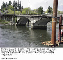
This included several bridges, all state offices in Olympia, and Boeing's factories in the Seattle area.
[16] Approximately $305 million of insured losses and a total of $2 billion worth of damage was caused in the state of Washington.
[17] Businesses that did not sustain very much damage also gained a sense of security that may be unreliable as the moment magnitude was high but the hypocenter was deep under the earth.
[17][18] Named after the Nisqually Delta, this earthquake hit the southern end of Puget Sound causing damage to the ports of Seattle and Tacoma.
[19][8] In the month following the earthquake, the National Oceanic and Atmospheric Administration and the USGS assembled a team to map the bathymetry of the deltas near the epicenter.
[20] Soil liquefaction was also observed at the Nisqually National Wildlife Refuge causing damage to the buildings within.