North American Cordillera
[3][4] The North American Cordillera extends from the U.S. state of Alaska to the southern border of Mexico, and includes some of the highest peaks on the continent.
[5] In the United States, another major feature of the Cordillera is the Columbia Plateau, located north of California between the Cascade Range – which is a northern extension of the Sierra Nevada[17] – and the Rocky Mountains.
Along the British Columbia and Alaska coasts, the mountains intermix with the sea in a complex maze of fjords, with thousands of islands.
Off the Southern California coast, the Channel Islands archipelago of the Santa Monica Mountains extends for 160 miles (260 km).
[23] Their coastal flank is characterized by an intense network of fjords and associated islands, very similar to the Norwegian coastline, while their inland side against the plateau transitions to the high plateau in dryland valleys notable for a series of large lakes similar to the alpine lakes of southern Switzerland, beginning in deep mountains and ending in flatland.
[23] The terrain of the main spine of the Coast Mountains is typified by heavy glaciation, including several very large icefields of varying elevation.
The Coast Mountains are made of igneous and metamorphic rock from an episode of arc volcanism related to subduction of the Kula and Farallon Plates during the Laramide orogeny about 100 million years ago.
The Insular Mountains extend from Vancouver Island in the south to Haida Gwaii in the north on the British Columbia Coast.
South of the Olympics lies the Chehalis River valley representing a break in elevation and drainages, followed by the Willapa Hills.
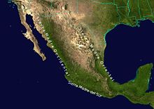
[29] The Sierra Madre del Sur mountains in southwestern Mexico form a southern extension of the Peninsular Ranges of Baja California.
[19] The Peninsular Ranges are separated from the Sierra Madre del Sur by an expanse of ocean.
The southernmost extends into Washington, where it is named by the American spelling Okanogan Highland (and was the first-named of these groupings).
The Sierra Nevada forms an inland mountain spine of northern California, extending from the terminus of the Cascade Range south of Lassen Peak southwards along the east flank of the Central Valley of California to the Transverse Ranges, forming a mountain region of complex terrain and varied geology which separates the Central Valley from the Great Basin to the east.
The mean height of the mountain summits in the Sierra Nevada gradually increases from north to south, culminating at Mount Whitney (14,505 feet (4,421 m)), the highest point in the contiguous United States.
[33] The range extends from near the Arizona border down to the Sierra Madre del Sur, along the western mainland of Mexico.
The Laramide belt is on the side of the North American Cordillera most distant from the Pacific Coast Ranges.
The Brooks Range forms the northern flank of the lower Yukon River basin, separating it from Alaska's North Slope region, facing the Beaufort Sea.
In the Rocky Mountains, the highest peak is Mount Elbert in Colorado at 14,439 feet (4,401 m) above sea level.
The American Rockies rise steeply over the Interior Plains to the east, and over the Great Basin to the west, and extend south to the Rio Grande in New Mexico.
The Okanagan Highland is described as being a hilly plateau, and is located in southern British Columbia and northern Washington.
The Central Valley is 40 to 60 miles (60 to 100 km) wide, with the Sierra Nevada to the east and the Coast Ranges to the west.
The Gulf of California is a body of water that separates the Peninsular Ranges from the Sierra Madre Occidental on the Mexican mainland.
The Columbia Plateau is a geologic and geographic region that lies across parts of the U.S. states of Washington, Oregon, and Idaho.
[44] It is a wide flood basalt plateau between the Cascade Range and the Rocky Mountains, cut through by the Columbia River.
The Green is a tributary of the Colorado, the confluence being west of Moab, Utah in Canyonlands National Park.
A low east–west mountain range in the state of Zacatecas divides the plateau into northern and southern sections.