The North China Craton is a continental crustal block with one of Earth's most complete and complex records of igneous, sedimentary and metamorphic processes.
[1][3][4] Basic properties of the cratonic crust include being thick (around 200 km), relatively cold when compared to other regions, and low density.
[1] However, the North China Craton later experienced destruction of some of its deeper parts (decratonization), which means that this piece of continent is no longer as stable.
[5] In the Paleoproterozoic (2.5-1.8 billion years ago) the continents collided and amalgamated and interacted with the supercontinent, creating belts of metamorphic rocks between the formerly separate parts.
[1] The thinning of the mantle root caused the craton to destabilize, weakening the seismogenic layer, which then allows earthquakes to happen in the crust.
[9] The Archean basement is overlain unconformably by Paleoproterozoic khondalite belts, which consist of different types of metamorphic rocks, such as graphite-bearing sillimanite garnet gneiss.
The most important deformation events are how the micro continental blocks collided and almagamated to form the craton, and different phases of metamorphism during Precambrian time from around 3 to 1.6 billion years ago.
[13][15] From 2.5 to 2.3 billion years ago, the Eastern and Western Blocks collided and amalgamated, forming the North China Craton with the Central Orogenic Belt in between.
[13] Kusky proposed that the tectonic setting of the amalgamation is an island arc, in which a westward dipping subduction zone was formed.
[12][13] Lastly, the tectonic setting of the craton became extensional, and therefore began to break out of the Columbia Supercontinent 1.8 billion years ago.
[2][5] He suggested that the Neoarchean (2.8–2.5 billion years ago) crust of the North China Craton, which accounts for 85% of the Permian basement, was formed in two distinct periods.
[17][18] The Xiong'er Volcanic Belt located in the Southern Margin of the craton recorded the accretion event of the Supercontinent in terms of a subduction zone.
[12] Zhao, on the opposite, argued that based on the lithological evidences, for example, the Eastern and Western Blocks must have been formed in settings different from the central part 2.6 to 2.5 billion years ago.
[27][4] The center of the craton remained stable until mid-Ordovician (467-458 million years ago), due to the discovery of xenoliths in the older lithosphere in kimberlite dykes.
[27][6] In Cambrian and Ordovician time, the units of limestone and carbonate kept a good record of biostratigraphy and therefore they are important for studying evolution and mass extinction.
[27][6] The Cambrian and Ordovician carbonate sedimentary units can be defined by six formations: Liguan, Zhushadong, Mantou, Zhangxia, Gushan, Chaomidian.
[51] Biomeres are small extinction events defined by the migration of a group of trilobite, family Olenidae, which had lived in deep sea environment.
[52][53] There are four regions where extensive iron deposits are found: Anshan in northeast China, eastern Hebei, Wutai and Xuchang-Huoqiu.
[52] Neoarchean greenstone belt gold deposits are located in Sandaogou (northeastern side of The North China Craton).
[52][54] The greenstone belt type gold deposits are not commonly found in the craton because most of them were reworked in the Mesozoic, so they appeared to be in some other form.
[52] Ultra high temperature metamorphic rocks found in the Paleoproterozoic Period indicate the start of modern tectonics.
[52][55] Magnesite – boron deposits were formed in sedimentary sequences under rift related shallow sea lagoon settings.
[52] In the Jiaoliao mobile belt, the GOE changed the isotopic ratio of 13C and 18O as the rock underwent recrystallization and mass exchange.
[52] The ore also allows people to further understand the Global Oxidation Event system, for example, showing the exact atmospheric chemical change during that period.
[57][58] Rare earth elements can make high quality permanent magnets, and are therefore irreplaceable in the production of electrical appliances and technologies, including televisions, phones, wind turbines and lasers.
[52] North China hosted a large reserve of molybdenum with more than 70 ore bodies found in the Northern margin of the craton.
[52] A rifting-subduction-collision processes in Danfeng suture zone generated VMS deposits (Cu-Pb-Zn) in the arc area and a marginal fault basin.
[52][59] During the opening of Paleo-Qinling oceans in this period, nickel-copper deposits formed with peridotite gabbro bodies and the ores can be found in Luonan.
[52] The origin of the gold is from Precambrian basement rocks of the Jiaodong Complex and underlying mantle which underwent high grade metamorphism when intruded with Mesozoic granitoids.
[62] Diamond bearing kimberlite pipes and dykes were emplaced during the Ordovician in the Archean crust between 450–480 million years ago and again in the Tertiary.
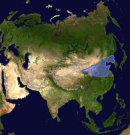
Tectonic elements surrounding the North China Craton. The North China Craton covers an area of around 1.7x10
6
km
2
in northeastern China, Inner Mongolia, the Yellow Sea, and North Korea. Edited from Kusky, 2007
[
1
]
and Zhao et al., 2005
[
2
]
The location of the North China Craton in Asia.
North China Craton consists of two blocks, the western and The Eastern Block, which are separated by a Trans-North China Orogen. The two blocks are of distinct characteristic.
[
2
]
[
1
]
A diagram of
Columbia Supercontinent
, which occurred in
Precambrian
time. The red part is the Western Block of the North China Craton, the purple part is the Eastern Block, the green part is the Trans-North China Orgen, and the blue part is other collision belts found in the North China Craton. Modified from Zhao et al., 2011
[
10
]
and Santosh, 2010.
[
11
]
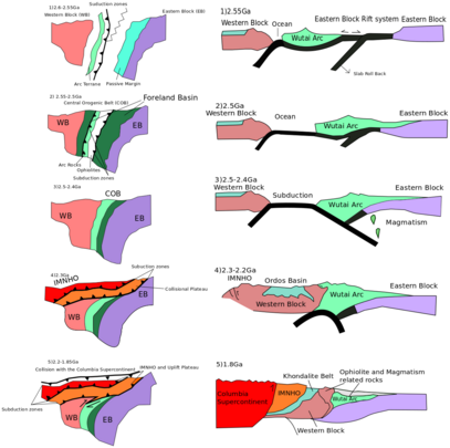
Evolutionary diagram of the 2.5 Ga
[a]
Craton amalgamation model (1st model) (Inner Mongolia-Northern Hebei Orogen) 1)-2) There was an ancient rift system caused by retreating subduction in the Eastern Block, which then later stopped.
[
12
]
[
13
]
3) A subduction zone developed between the Eastern and Western blocks, with some magma plumes developed and exhumed as the plate was subducted.
[
12
]
[
13
]
The North China Craton finally amalgamated.
[
12
]
[
13
]
4) The Western Block further interacted with an arc terrane in the north with a subduction zone and formed the Inner Mongolia-Northern Hebei Orogen.
[
12
]
[
13
]
5) The North China Craton collided with the
Columbia Supercontinent
, causing deformation and metamorphism in the region.
[
12
]
[
13
]
Modified from Kusky, 2011
[
12
]
and Kusky, 2003
[
13
]
A cross-sectional diagram of the 1.8 Ga amalgamation model (the second model).
[
9
]
The amalgamation of the two blocks was caused by subduction.
[
9
]
The subducted oceanic plate caused the hydration of the lithosphere, therefore producing magma plumes (denoted in green).
[
9
]
They later contributed to the formation of the Trans North China Orogen.
[
9
]
The 2 blocks further collided and amalgamated, forming the Khondalite belt, the Jiao-Liao-Ji Belt and the Trans North China Orogen.
[
9
]
After the craton was formed, the Trans North China Orogen experienced exhumation, isostatic rebound, and erosion, changing the orientation of rocks in the orogen.
[
9
]
Modified from Zhao, 2000
[
9
]
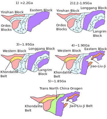
A map view diagram showing the evolution of the North China Craton in the 1.85 Ga amalgamation model.
[
5
]
1) The craton began as 3 separate blocks, the Yinshan Block, the Ordos Block and the Eastern Block with oceans between them (2.2 billion years ago).
[
5
]
2) A rift system developed in the Eastern Block that further separated it into 2 blocks, the Longgang Nlock and the Langrim Block (2.2–1.95 billion years ago).
[
5
]
3) The Yinshan Block and the Ordos Block amalgamated 1.95 billion years ago, forming the Khondalite Belt in between.
[
5
]
4) The rift system between the Longgang Block and the Langrim Block stopped finally, causing the blocks to amalgamate into the Eastern Block again, forming the Jiao-Liao-Ji Belt 1.9 billion years ago.
[
5
]
5) the Eastern and Western Blocks finally amalgamated 1.85 billion years ago, forming the Trans-North China Orogen in between.
[
5
]
Modified from Zhao, 2012.
[
5
]
This map view diagram shows how Zhao proposed the micro blocks would have been oriented and amalgamated into North China Craton. He derived the map based on the age of the greenstone belts found in the Craton. He suggested that the greenstone belt was formed by collision of some micro blocks.
[
19
]
[
20
]
[
21
]
The green belt on the map shows a younger greenstone belt, formed 2.5 billion years ago, while the yellow one showed the greenstone belt formed 2.6–2.7 billion years ago.
[
19
]
[
20
]
[
21
]
(QH: Qianhuai Block, Jiaoliao Block:JL, Jining Block:JL, Xuchang Block: XCH, Xuhuai Block: XH, Alashan Block: ALS) Modified from Zhai, 2011
[
19
]
This cross-section diagram shows how the North China Craton amalgamated in the Faure and Trap Model. They proposed that the Trans-North China Orogen that is mentioned in Zhao and Kusky's model is actually a separated block.
[
22
]
[
23
]
[
24
]
There are 2 collision and amalgamation events as proposed by Faure and Trap.
[
22
]
[
23
]
[
24
]
At 2.1 billion years ago, the Taiahng Ocean closed with the Eastern Block and Fuping Block amalgamated through Taihang Suture (THS).
[
22
]
[
23
]
[
24
]
At 1.9–1.8 billion years ago, the Lüliang Ocean closed and the Eastern and Western Blocks finally amalgamated forming the Trans-North China Suture (TNCS).
[
22
]
[
23
]
[
24
]
Modified from Trap and Faure, 2011.
[
25
]
This is a map showing the different tectonic elements near the North China Craton in the Phanerozoic.
[
41
]
The elements includes the Solonker suture zone in the north, the Paleo-Pacific subduction zone in the east, and the Qinling Dabie Orogen in the south.
[
41
]
Modified from Zhu, 2015
[
41
]
The green lines on this lithospheric thickness map are lithospheric depth contour lines, meaning that the lithosphere is of the depth specified in that position.
[
29
]
A zone in the Eastern Block has especially thinned lithosphere.
[
29
]
Modified from Windley, 2010,
[
29
]
This is a diagram showing an example of the subduction model by Kusky, 2007. 1) plates are subducted under the North China Craton near the margin in the Paleozoic with most part of the craton remained relatively stable.
[
1
]
The subduction generated fluids which weakened the lower crust.
[
1
]
At the same time, subduction increased the density of the lower lithosphere.
[
1
]
2) & 3) In the Mesozoic, the North China Craton begins to experience deformation.
[
1
]
The collisions in the north and south triggered the weakened lower lithosphere to detach.
[
1
]
Modified from Kusky, 2007
[
1
]
This is a diagram showing how lithosphere can be thinned by retreating subduction. The yellow star shows where the thinned lithosphere is. The lithosphere thinned because the subducting plate roll back faster than the over-riding plate could migrate forward.
[
38
]
As a result, the over-riding plate stretch its lithosphere to catch up with the roll back, which resulted in lithospheric thinning.
[
38
]
Modified from Zhu, 2011.
[
38
]
This is a diagram showing how the lithosphere can be thinned through folding in map and cross section. Folding occurs when the Yang Tze Craton and the North China Craton collided.
[
32
]
Week points and dense
eclogites
were developed in the lower crust.
[
32
]
They are later fragmented and sank because of convection of asthenosphere.
[
32
]
Edited from Zhang, 2011.
[
32
]
Trilobite fossil that can be possibly used for biostratigraphy and to understand evolution and extinction
Banded iron formation example from another part of the world
Production of REE around the world
Described the tectonic processes of The North China Craton northern margin in the Palaeozoic.
[
1
]
[
52
]
The subduction and collision event caused minerals to deposited on the edge of the continental crust.
[
1
]
[
52
]
The place where the Cu-Mo was deposited is indicated.
[
1
]
[
52
]
Edited from Zhai and Santos,2013 and Kusty et al., 2007
[
1
]
[
52
]