North Fork Toutle River
[4] The largest tributary is the Green River, which joins near the unincorporated town of Toutle.
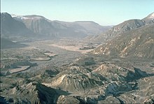
The North Fork's watershed was severely affected by the 1980 eruption of Mount St. Helens, which coated the valley with ash and filled it with successive mudflows.
Once a mature river, the North Fork has transformed into a braided stream of relatively young origin, and its valley floor is less than three decades old.
The upper part of the North Fork Toutle River watershed was redirected to the crater of Mount St. Helens itself until 1982.
The river's headstreams begin on a volcanic ash deposit roughly 3 miles (5 km) long and 200 feet (61 m) deep, which is the source of much of the excess sediment.