Oatka Creek
Like its parent stream it originated during the end of the last Ice Age, as glacial impact on the upper Allegheny Plateau created a rolling landscape streams could gradually erode through, The Oatka carved a deep groove known today as the Oatka Valley, where the upper creek's two major settlements would be established.
Several small streams, some of which ultimately rise to the north at elevations of almost 1,600 feet (490 m), come together to create the main stem of the creek amid the fields and woodlots on the high plateau in Gainesville just south of the Warsaw town line, a short distance west of Silver Spring Road.
The new stream flows first south a mile, then turns northwest paralleling the Norfolk Southern railroad tracks toward the small hamlet of Rock Glen.
To the west of Rock Glen, it passes through the narrow gorge that gave it its name, emerging at another hamlet, Newburg, at the head of the Oatka Valley it follows for the rest of its run.
It enters the village of Le Roy on a northeast course, crossing Route 19 again as it widens into a 26-acre (11 ha) reservoir behind the dam just south of NY 5.
After going over the 60-foot (18 m) falls, marking the Onondaga Escarpment, it turns east, leaving NY 19 a mile south of the New York State Thruway.
Almost all of the towns of Warsaw, Pavilion and Le Roy are within the watershed, along with large portions of Covington, Gainesville, Middlebury and Wheatland.
[5] The United States Geological Survey maintains two stream gauges on the creek, at Garbutt near the mouth and Warsaw below its headwaters.
[6] Only one community along the creek, the village of Warsaw, uses it as a water supply, putting it through a filtration plant before distributing it to residents and other customers.
Most chemicals within it are within normal limits, with slightly higher levels of sulfates due to the gypsum and dolomite present in the bedrock.
Accordingly, the state's Department of Environmental Conservation (DEC) classifies the Monroe and Genesee sections of the stream as "threatened", since some issues could arise in the future.
The Wyoming County portion is considered "stressed", in that while its quality is generally good, occasional issues arise that limit use.
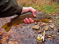
The state fish hatchery on Spring Creek near Caledonia stocks the stream annually, and there is also evidence of a wild trout fishery on the stretch between Bowerman and Wheatland Center roads.
A 1999 survey estimated the creek's total trout biomass at 30 pounds per acre (33 kg per hectare) bass, walleye and northern pike have also been taken near the Genesee.
[13] As the glaciers retreated 12,000 years ago the landscape they left behind on the Allegheny Plateau was a rolling expanse of drumlins and depressions in which meltwater and precipitation could accumulate.
[15] In 1779, during the Revolutionary War the Continental Army's Sullivan Expedition came into Western New York to suppress Senecas who had professed loyalty to the British or might do so.
In the 1790s settlement progressed upstream with the establishment of Le Roy where the stream intersected an old Indian trail that later became New York State Route 5.
Settlement moved quickly afterwards, with all present communities as far south as Gainesville seeing their first settlers in the opening years of the 19th century, when the Holland Land Company owned much of it.
[15] The only significant change made to the river by human engineering is the dam at Le Roy near where Route 5 crosses the creek.
These include both the longest, the 227-foot (69 m) crossing over the lake created by the Le Roy dam,[17] northernmost along Route 19, and the shortest and southernmost, its 29-foot (8.8 m) bridge south of Rock Glen.
Today the creek's direct economic value comes from its role as a water supply and discharge for the wastewater of the two most populous villages along it, Le Roy and Warsaw.
The narrow and deep Oatka Valley was a preferred transportation corridor through eastern Wyoming and Genesee counties.
The upper creek, above Warsaw, is stocked with 1,850 yearling brown trout in the spring of each year, supplementing an indigenous wild population.
DEC surveys have found that by June few of the stocked trout remain, showing that the stretch has heavy fishing pressure.
The groundwater infusions from the Blue Hole and falls cool the creek again; from the bend eastward to its mouth it is a freestone stream with a large population of stocked and wild brown trout.
The 11,200 fry added to the waters each year come from the state fish hatchery north of Caledonia on the Oatka's Spring Creek tributary established in 1864 by Seth Green,[20] the oldest such facility in the Western Hemisphere.
Brown trout was first introduced to American waters from it; today the 170,000 pounds (77,000 kg) of fish produced supply almost all of the state's stocked streams.
The 1.7-mile (2.7 km) section in Oatka Creek Park is the most frequently used, since special regulations to conserve the wild trout population there allow no-kill fishing there with artificial lures year-round.
Similar rules apply between October and March in the less-accessible stretch downstream of the park to Bowerman Road; during the regular season anglers are limited to two fish per day at a 12-inch (30 cm) minimum.
DEC has also acquired public fishing easements on a small stretch in Mumford and much of both banks along Oatka Trail in the Town of Le Roy between Mud Creek and the unnamed northern tributary two miles (3.2 km) upstream.