Ohio State Route 338
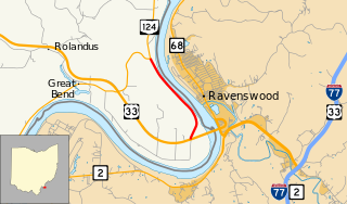
At the time of its removal from the state highway system, the last remnant of the route was a 2.3-mile-long (3.7 km) segment (designated by the Ohio Department of Transportation (ODOT) as SR 338-J) between US 33 near the Ravenswood Bridge and SR 124.
A field is visible to the east, as the highway made its namesake turn as Great Bend Road.
With the Ohio River in view, the highway terminated at an intersection with SR 124 northeast of Racine.
[2] The original route was certified in 1932; originally routed from Letart Falls (about 6 miles (9.7 km) south of Racine) to 10 miles (16 km) east of Letart Falls.
[11] ODOT was making constant repairs to SR 338 due to its close proximity to the river, which led to soil instability.