Oil shale in Estonia
[7] Shortly thereafter, systematic research into oil shale and its products began, and in 1938 a department of mining was established at Tallinn Technical University.
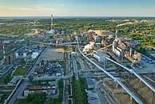
Increased need for electricity in the north-west of the Soviet Union led to the construction of large oil shale-fired power stations.
[12] In mainland Estonia, it occurs at the foot of the North Estonian Klint, ranging from the Pakri Peninsula to Narva in an area covering about 11,000 square kilometres (4,200 sq mi).
[8][12] Although resources of graptolitic argillite exceed that of kukersite, attempts to use it as an energy source have been unsuccessful due to its low calorific value and high sulfur content.
[15] It was named kuckers by the Baltic German geologist Carl Friedrich Schmidt in the mid-19th century, and kukersite by the Russian paleobotanist Mikhail Zalessky in 1916.
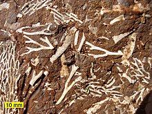
[21] The principal organic component of kukersite is telalginite, which originated from the fossil green alga Gloeocapsomorpha prisca, deposited in a shallow marine basin.
[28][29] Economically proven and probable reserves consist of mineable deposits with energy ratings of at least 35 gigajoules per square metre and calorific values of at least 8 MJ/kg, located in areas without environmental restrictions.
[31] It is also often reported that the earliest documented record of oil shale in Estonia, authored by the Baltic German publicist and linguist August Wilhelm Hupel, dates to 1777.
[31] In the second half of the 18th century, the St. Petersburg Free Economic Society started to search for information about combustible minerals which as fuels would replace the decreasing stock of trees in the European part of Russia.
[31] This discovery was briefly mentioned in a paper prepared by the German chemist Johann Gottlieb Georgi and presented by the Actual State Councillor Anton-Johann Engelhardt at the meeting of the Society in 1789.
[17][31][32] The first scientific research into the rock's oil yield, using samples from the village of Vanamõisa of the Kohala Manor, was published by Georgi at the Russian Academy of Sciences in 1791.
[26][31] In 1838 and 1839, the Baltic German geologist Gregor von Helmersen published a detailed description of the deposits of kukersite in Vanamõisa and graptolitic argillite in Keila-Joa.
In the years 1850–1857, the territory of Estonia was explored by the Baltic German geologist Carl Friedrich Schmidt who studied these findings of oil shale.
In the beginning of the 20th century, geologist and engineer Carl August von Mickwitz studied self-ignition of graptolitic argillite near Paldiski.
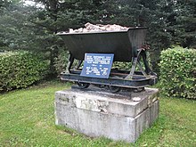
[26][37] Analysis of Estonian oil shale resources and mining possibilities intensified during the early 20th century while Estonia was part of the Russian Empire.
[37] In June 1916, the Russian geologist Nikolay Pogrebov oversaw mining of the first tonnes of oil shale at Pavandu and delivered it to Saint Petersburg (then Petrograd) Polytechnic Institute for large-scale experiments.
[17] Based on these promising results, a plan for oil shale mining in Estonia was presented to the Emperor Nicholas II on 3 January 1917.
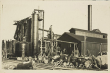
During this occupation, mining activities were carried out at Pavandu by the German company Internationales Baukonsortium (English: International Construction Consortium), including sending oil shale to Germany for research and experimentation.
[63] On 21 June 1943, Reichsführer Heinrich Himmler issued an order to send as many male Jews as possible to the oil shale mining.
[63][64] Baltische Öl consisted of five units (Kiviõli, Küttejõu, Kohtla-Järve, Sillamäe, and Kohtla), all of which were partially restored, previously existing industries.
[9][12] Some sources note that uranium produced in Sillamäe was used for construction of the first Soviet atomic bomb; however, this information is not confirmed by the archive materials.
[34] In the 1990s, after Estonia regained independence, the country underwent a restructuring of the economy, causing the collapse of a large part of the heavy industry sector.
As a part of the deal, 51% of the government-owned shares in the oil shale mining company Eesti Põlevkivi was transferred to the Narva Power Stations.
The venture sought to develop and commercialise a modified Galoter process–the Enefit process–that would enhance the existing technology by using circulating fluidised beds.
[128] The share of oil shale in Estonia's electricity generation has decreased significantly over the last decade,[129] and it is set to decrease even more due to the European Union's climate policy as well as the country's recognition of the environmental impact of oil shale-fired power stations and need to diversify the national energy balance.
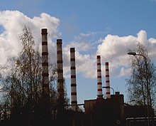
[134] The co-generation plants in Kohtla-Järve, Sillamäe, and Kiviõli burn oil shale to produce electrical power and supply district heating to nearby towns.
[144] The waste material, particularly semi-coke, contains pollutants including sulphates, heavy metals, and polycyclic aromatic hydrocarbons (PAHs), some of which are toxic and carcinogenic.
[146] Before the closure of old semi-coke heaps in Kohtla-Järve and Kiviõli, an additional 500,000 cubic metres (410 acre⋅ft) of leachates reached via the Kohtla and Purtse rivers to the Baltic Sea annually.
Fluidised bed combustion generates fewer NOx, SO2, and fly-ash emissions, including PAHs, than the earlier technologies that burned pulverised oil shale.
[147] An oil shale sector health impact study conducted in 2014–2015 show that the residents of the region complained significantly more frequently about tightness, long-term cough, phlegm in the lungs, wheezing and cardiovascular diseases, hypertension, stroke, diabetes and stenocardia.