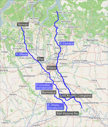
Olona
[20] In Gorla Minore the river branches off into the Olonella, which joins the main riverbed after 1200 m.[7][21] In this stretch, many artificial canals are born in the service of agriculture and of the industries that re-enter the Olona before Castellanza.
[4] Entering Pero, after an initial stretch still outdoors, the Olona begins to flow under the road surface and reaches Milan[3][27] by first crossing the Gallaratese, Lampugnano and QT8 districts, where it collects the water of the Merlata river (also called Fugone), to then skirt the southern slope of Monte Stella.
[4] The path under the ring road, which was designed for the first time on the General Plan of Milan in 1884 (the so-called Piano Beruto),[28] was channeled in the first two decades of the 20th century[28] and covered in a period from 1950 to 1970.
The two Olona do not have an autonomous hydrography: at Rozzano, from the Lambro Meridionale, a branch take off towards the south-west, gaining vigor thanks to the water supply provided by springs and artificial canals.
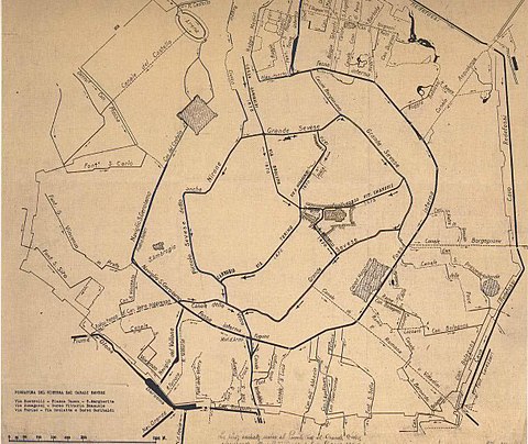
[37][38] Until ancient Roman times, at La Maddalena, today's quartier of Milan, the Olona was diverted towards the city with the aim of bringing water to it: in ancient Roman times it flowed into the moat of the republican defensive walls of the city of Mediolanum[39] then, from the 12th century, in the defensive moat around the medieval walls[28] and later (1603) in the Darsena of Porta Ticinese.
[40] In particular Olona river, during the Middle Ages, flowed into the moat of medieval defensive walls of the city in correspondence of the modern Piazza della Resistenza Partigiana, while in ancient Roman times it continued the city route reaching the modern Piazza Vetra, where it poured its water into the moat of Roman walls thanks to the homonymous canal, the Canale Vetra.
[42] The new artificial riverbed of the Olona was then excavated from scratch only for a short distance: having reached the modern Lucernate at the Bozzente stream, the designers widened their bed to accommodate a greater water flow.
[48] In this context, in 1894, Canottieri Olona was founded, a multi-sports club in Milan, winner of an Italian men's water polo championship, based in the Darsena of Porta Ticinese.
[28] The first covering carried out in Milan on the course of the Olona occurred in 1935 on part of the Darsena branch (from Via Valparaiso to Viale Coni Zugna), when instead of the cattle station of the railways that stood there was built the Solari Park.
[53] Other toponyms that were used during the history to refer to the Olona are Ollona (appeared in a document dated 737 AD), Oleunda (1033), Orona (mid-16th century) and Olonna (reported in 1688 on the Ravenna Cosmography).
[58] The oldest prehistoric finds found in the areas around the natural Olona riverbed are bos primigenius bones dating back to the Würm glaciation.
[70] The chronologically later furnishings, two bronze spearheads linked to the archaic Golasecca culture and always found in Legnano, date back to between the 9th and 8th centuries BC (early Iron Age).
[69] In Roman times, the shores of the Olona assumed significant importance due to their strategic position with respect to the communication routes between the Po valley and the Alps.
[77] In the 1st century AD, along the route drawn by the course of the river, an ancient Roman road was built, the via Severiana Augusta, which connected Mediolanum (modern Milan) with the Verbanus Lacus (Lake Maggiore),[78] and from here to the Simplon Pass (lat.
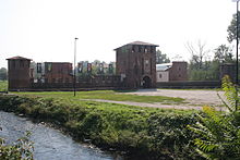
[87] Having become part of the Duchy of Milan and already protected for centuries by a chain of fortresses and castles,[88] the shores of the Olona increased their development: the mills multiplied, while the contribution to irrigation remained significant.
[97] After 1820, the first proto-industrial activities started along the Olona began to exploit the motive power of the river by first purchasing, and then modifying in the most appropriate way, the water mills that for centuries were destined for the grinding of agricultural products.
[132] The most important ones are the Lura, the Bevera, the Gaggiolo (also called "Lanza"), the Bozzente, the Vellone, the Rile, the Tenore, the Merlata, the Pudiga, the Quadronna, the Selvagna and the Fredda.
[144] As long as it was in operation, the stretch of the Cavo Diotti that took water from Castegnate, frazione of Castellanza, represented the most important artificial derivation of the Olona.
[146][147] The southern section of this artificial channel, that is the one that extracted the water previously introduced in Castegnate, was instead buried in 1918 following the strong urbanization of the agricultural area of Pantanedo, frazione of Rho, which was the final user of the Cavo Diotti.
[161] On the summit of the Campo dei Fiori massif these plant species are replaced by beech,[161] while birches and Scotch pines are common on the dry slopes of Monte Martica.
[116] The flora of the flat stretch of the Olona, which includes most of the river's path, is characterized by the massive presence of the black locust, native to North America and introduced in the Italian woods, as well as by the species of high trunk already mentioned at the beginning of the 19th century to consolidate the railway ballast.
[116][161][165] There are also several birds of prey: some resident like the northern goshawk, the black kite, the honey buzzard, the sparrow hawk and the peregrine falcon, others migratory such as the short-toed snake eagle and the marsh harrier.
Among them, along the shores of the Olona, one can find the nutria, the American semiaquatic rodent, the spinycheek crayfish and the eastern gray squirrel,[165] while in its waters it is possible to catch catfish.
[171] It is not possible to speak of navigability even in the 21st century, even if in some points of the river canoeing is practiced and occasionally, for environmental promotion purposes, some ecologists carry out the descent by kayak.
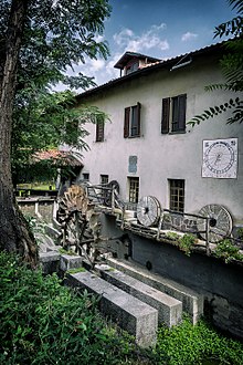
[100] In Legnanese there are only six:[100] these are the Cornaggia of Legnano, Meraviglia (formerly Melzi Salazar), Cozzi, De Toffol, Montoli of San Vittore Olona and Galletto of Canegrate mills.
The buildings, between naturalism, classicism, Egyptian and floral, present striking decorations: masks, grotesques, medallions, fringes and drops, shells, giant pilasters and large festoons of hops.
The Campo dei Fiori Regional Park[227] covers an area of 6,300 hectares and is managed by a consortium formed by the Valli del Verbano mountain community, the Piambello mountain community, the province of Varese and the seventeen municipalities included in the Park territory: Barasso, Bedero Valcuvia, Brinzio, Casciago, Castello Cabiaglio, Cocquio-Trevisago, Comerio, Cunardo, Cuvio, Gavirate, Induno Olona, Luvinate, Masciago Primo, Orino, Rancio Valcuvia, Valganna and Varese.
The Parco Rile Tenore Olona,[163] which was established in 2006, embraces a territory characterized by extensive terracing of fluvial-glacial origin, the so-called moraine plains, and is rich in sites of historical and cultural significance.
In addition to the Valle Olona, the park also includes the Fagnanese stretch of the Tenore and the woods to the east of Gorla Maggiore, where the Fontanile di Tradate flows.
The Parco dei Mulini,[233] which was established on 20 March 2008, covers the wooded and agricultural areas of the municipalities of Legnano, Canegrate, San Vittore Olona, Parabiago and Nerviano.