Pan-American Highway
It is recognized as the longest road in the world and serves as a significant overland route connecting multiple countries across the Americas.
The highway traverses through 14 countries in total, including Canada, the United States, Mexico, Guatemala, El Salvador, Honduras, Nicaragua, Costa Rica, Panama, Colombia, Ecuador, Peru, Chile, Argentina, and Bolivia.
[1] The third stage, which has not been completed and may never be, continues onward to the southern tip of South America at Tierra del Fuego National Park, near Ushuaia, Argentina.
Finally, on July 29, 1937, in the latter years of the Great Depression, Argentina, Bolivia, Chile, Colombia, Costa Rica, El Salvador, Guatemala, Honduras, Mexico, Nicaragua, Panama, Peru, Canada, and the United States signed the Convention on the Pan-American Highway, whereby they agreed to achieve speedy construction, by all adequate means.
Highway 97 as it passes through Toad River Post, and then Summit Lake, which is nested between Stone Mountain and Mount Saint George.
Interstate 5 in the United States connects to Mexican Federal Highway 1 at the busiest international border crossing in the world.
[17][18][19] In the inaugural Carrera Panamericana road race, organized by the Mexican government, the terminus of this southern route was said to be at Ciudad Cuauhtémoc, Chiapas, at the Guatemalan border.
It passes through Liberia, San José, Cartago, Pérez Zeledón, Palmares, Neily, before crossing into Panama at Paso Canoas.
The highest point in the entire Pan-American Highway occurs at the Cerro de la Muerte (Death Hill) in the Carretera Interamericana Sur segment, at 3,335 m (10,942 ft).
The Talamanca range, which is non-volcanic, includes Cerro Chirripó, Costa Rica's highest mountain peak at 3,820 metres (12,530 ft).
David, the capital of the Chiriqui Province, is located about 8 km (5.0 mi) north of the town of Pedregal and the Gulf of Chiriquí.
From Penonomé, the highway travels southeast, then northeast, then roughly north in a loop as it avoids crossing into Panama's Central Mountains.
A 1962 expedition with three Chevrolet Corvair rear-engine cars and two support trucks completed the trip south from Chicago through to the Colombian border.
[26] In 1979, a team led by Mark Smith drove standard production CJ7-model Jeeps from South to North, traversing the Gap with difficulty.
[27] In 1984, Loren and Patty Upton made the first "all land" vehicle crossing of the Gap using a 1966 Jeep CJ-5 named Sand Ship Discovery.
The main route of the Pan-American Highway in Colombia (starting from the northeast) begins just east of Cúcuta, the capital city of the department of Norte de Santander.
From the department border, Route 66 continues southwest for 50 km toward Bucaramanga, state capital of Santander located on a plateau in the Cordillera Oriental.
The road ends at Venezuela Highway 9 in Güiria, a small town in the state of Sucre just west of Trinidad along the Gulf of Paria coastline.
About 34 km west of Boca de Uchire, the highway starts climbing up the Cordillera Central, in the Andes mountains.
From Maracay the highway extends about 44 km to Valencia, passing San Joaquin and near Cuacara en route to the city.
From Barquisimeto, Highway 1 continues roughly west, then southwest (at around Agua Salada) for 147 km to the state line with Trujillo, near El Empedrado.
From the junction to the city of San Cristóbal the distance is 44 km, although there is a separate expressway that parallels the Pan-American Highway along this stretch.
[33] The highway network also continues south of Buenos Aires along Argentina National Route 3 towards the city of Ushuaia in Tierra del Fuego.
The highway does not have official segments to Belize, Guyana, Suriname (there known in Dutch: Pan-Amerikaanse weg), and French Guiana, nor to any of the island nations in the Americas.
Mexico has already surveyed a route which will run across the Yucatán, Campeche, and Chiapas to San Cristobal de Las Casas, on the Pan American Highway.
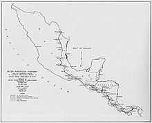
("The Pan American Highway System" by Travel Division Pan American Union, Washington D.C. October 1947) Travel writer Tim Cahill wrote a book, Road Fever, about his record-setting 24-day drive from Ushuaia in the Argentine province of Tierra del Fuego to Prudhoe Bay in the U.S. state of Alaska with professional long-distance driver Garry Sowerby, much of their route following the Pan-American Highway.
[34] In the British motoring show Top Gear, the presenters drove on a section of the road in their off-road vehicles in the Bolivian Special.
In 2003, Kevin Sanders, a long-distance rider, broke the Guinness World Record for the fastest traversal of the highway by motorcycle in 34 days.
[36] Stott was inspired to push the timetable after learning that he and his wife had been invited to the wedding of Prince Harry and Meghan Markle, and would have missed the event had he stuck to his original schedule.
[38][39] In 2024, American endurance cyclist Bond Almand IV broke Strasser's record, riding north-to-south in 75 days, 17 hours, and 55 minutes (August 31 – November 15, 2024).