Peace River Country
It extends from northwestern Alberta to the Rocky Mountains in northeastern British Columbia, where a certain portion of the region is also referred to as the Peace River Block.
The Peace River Country includes the incorporated communities of Fort St. John, Dawson Creek,[1] Tumbler Ridge and Chetwynd in British Columbia.
The term is used also in a broader sense to mean the whole of the Northeastern Interior past the Rockies, including Fort Nelson and other parts of the Liard drainage, and before W.A.C.
Bennett Dam included the upper Peace River through its canyon between Finlay Forks and Hudson's Hope.
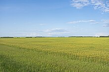
At the beginning of the 20th century, the farming potential of the area was advertised by the federal government, but a settlement was scarce because of difficult travel conditions through the muskeg.
The settlement of the British Columbia portion of the agricultural area, known as the Peace River Block, originated as a railway grant which wound up for a time under Dominion jurisdiction and managed by offices in Alberta until returned to British Columbia following ongoing jurisdictional conflicts.