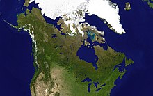
Canadian canoe routes
This article covers the water based Canadian canoe routes used by early explorers of Canada with special emphasis on the fur trade.
The fur trade, principally in beaver, drove and financed exploration and initial settlement.
In Siberia a band of armed Cossacks would enter a native village and demand yasak or tribute.
European settlement of Canada began in 1583 (St. John's), 1605 (Port Royal, Nova Scotia), and 1608 (Quebec City).
Canada-based Europeans reached the Arctic Ocean in 1789 and the Pacific in 1793, both expeditions led by Alexander Mackenzie.
Early sea ships could follow the Hudson River as far as Albany, but this leads north to the Saint Lawrence and westward travel was blocked by the Iroquois league.
French Era: In the 16th century, cod fishermen began trading for furs, especially at Tadoussac on the St. Lawrence River.
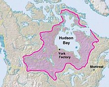
Meanwhile, the British maintained posts on Hudson Bay, ignored the interior and waited for Indians to bring furs to them.
After the British conquered Canada in 1759, management of the Montreal trade was taken over by English-speakers while the real work continued to be done by French-Canadians.
Since the west country was too far for a round trip in one season, each spring, when the ice broke up, boats would set out from Montreal while winterers would start east.
They exchanged their goods at Grand Portage on Lake Superior and returned before the rivers froze five months later.
To save the cost of hauling food from Montreal, Metis around Winnipeg began the large-scale production of pemmican.
The Hudson Bay trade was diverted southwest to the edge of the prairie where pemmican was picked up to feed the voyageurs on their journey northwest to the Athabasca country.
Routes ran from the French River south to the Jesuit Huron missions at the southern end of Georgian Bay (1626–1640), west through the Strait of Mackinac to Lake Michigan, or west north of Manitoulin Island and up the St Marys River (26 feet difference in elevation) to Lake Superior.
On Lake Superior voyageurs would normally hug the northern shore because of the danger of frequent squalls that could overturn their boats.
From here to Lake of the Woods the voyageurs' route went northwest across the 9 mile (14 km) long Grand Portage to avoid the falls and canyon of the Pigeon River, thence along the present international border west up the 50 miles (80 km) long Pigeon River and Arrow River to South Lake, and then across the 400 metres (1,300 ft) Height of Land Portage to North Lake whose waters drain into Hudson Bay.
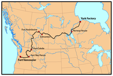
The Hayes route became more important after 1821 when much trade shifted from Montreal to York Factory) In 1803 it was found that Grand Portage was on the US side of the border and the Lake Superior base was moved 45 miles (72 km) northeast to Fort William, Ontario, from which an old trail led inland to the north and west to Lac La Croix in the watershed of the Rainy River.
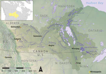
There are no portages between Cumberland and Edmonton, but there are sand bars and 125 miles (201 km) stretch of strong current east of Prince Albert, Saskatchewan where canoes were dragged upstream on ropes.
Above Prince Albert is the La Montée prairie country where voyageurs were fed by buffalo hunters.
The Red River of the North, which flows north into the southern tip of Lake Winnipeg gained some importance after 1812 with the establishment of the Red River Colony and when the Metis began supplying buffalo Pemmican to feed the voyageurs.
This was about as far as canoes could reach and return in one season and was the gathering place for furs from the rich Athabasca region and further west.
A Maritime fur trade with China developed from the Columbia District (known as Oregon Country in the US).
The inland canoe routes were linked to the Pacific coast in 1811 when David Thompson reached the mouth of the Columbia River.
The far northwest was supplied by an unusual route which was found in 1851 by Robert Campbell who travelled in the opposite direction from the one described here.
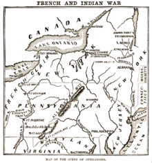
From about 1715 the French sought to link the St. Lawrence and Mississippi basins and bottle up the English on the east coast.
[6][7] By the time of the British conquest there were French trading posts from New Orleans up the Mississippi and Illinois Rivers to the Great Lakes.
Movement inland began about 1750 after the French entered the western country and tried to divert the Hudson Bay fur trade to Montreal.


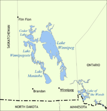
The Nelson River drains Lake Winnipeg northeast into Hudson Bay.
The Red River comes in from the south.