Pearl River (Mississippi–Louisiana)
It forms in Neshoba County, Mississippi from the confluence of Nanih Waiya and Tallahaga creeks,[1] and has a meander length of 444 miles (715 km).
[3] The mouth of the river creates important marsh habitat along salinity gradients, which has been the subject of many scientific studies.
The Pearl River serves as the 115-mile (185 km) boundary between Mississippi and Louisiana[2] in its lower reach near the Gulf of Mexico.
Pearl River provides the receiving waters for the Savanna Street Sewage Treatment Plant in Jackson, Mississippi.
[15] The customhouse at Pearl River which was ten miles inland at the small town of Pearlington, Mississippi was later changed,[16] but in 1904 the district reported a total of 358 vessels and 19,869 tons.
Beginning in 1910, a channel was dredged from the mouth of the East Pearl River into Lake Borgne, a project which is maintained on an irregular basis.
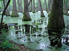
[20] Building dams, canals, levees and water control structures is known to have highly negative effects on wetlands and the ecological services they provide.
[24] Hurricanes are a natural form of disturbance that shapes rivers and watersheds on the Gulf Coast, and has done so for thousands of years.
Bottom sediments and marsh vegetation—including uprooted cypress and oak trees—blocked the mouth of the West Pearl and other parts of the channel.
[27] However, the accumulation of this woody debris is a natural part of floodplain ecosystems in general, and wetlands in particular, and provides vital habitat for species including fish and turtles.