Schuylkill Expressway
Maintenance and planning for most of the highway are administered through Pennsylvania Department of Transportation (PennDOT) District 6, with the Delaware River Port Authority (DRPA) maintaining the approach to the Walt Whitman Bridge.
[7] The Schuylkill Expressway begins at the Valley Forge interchange of the Pennsylvania Turnpike in the community of King of Prussia in Upper Merion Township, Montgomery County.
Past the toll plaza, the Schuylkill Expressway narrows to four lanes, with two lanes in each direction, and comes to an eastbound exit and entrance with North Gulph Road, providing access to Valley Forge National Historical Park and the Village at Valley Forge residential and retail development, the latter of which contains the King of Prussia Town Center lifestyle center, and a westbound exit and entrance with Mall Boulevard, providing access to the King of Prussia shopping mall to the northeast of the road.
The freeway passes businesses and comes to an interchange with U.S. Route 202 (US 202), the eastern terminus of US 422, and Swedesford Road that serves King of Prussia.
The Schuylkill Expressway curves southeast near wooded areas of homes before coming to an interchange with Pennsylvania Route 320 (PA 320) in the community of Gulph Mills.
[8][9] Past the I-476 interchange, the Schuylkill Expressway heads east and comes to a westbound exit and eastbound entrance providing access to PA 23 and Conshohocken, passing near residential and commercial development.
Farther southeast, the Schuylkill Expressway crosses Mill Creek and comes to a westbound exit and eastbound entrance with Hollow Road that provides access to the community of Gladwyne.
The freeway passes over the Flat Rock Tunnel carrying Norfolk Southern Railway's Harrisburg Line and continues to the southeast with the Schuylkill River to the northeast and the railroad tracks to the southwest.
Following this interchange, the freeway passes under the Manayunk Bridge that carries an extension of the Cynwyd Heritage Trail across the Schuylkill River.
The Schuylkill Expressway passes over Norfolk Southern Railway's Harrisburg Line and runs southeast between the West Laurel Hill Cemetery to the southwest and an industrial area to the northeast that is sandwiched between the railroad tracks and the river.
I-76 comes to a diamond interchange with Montgomery Drive that provides access to Fairmount Park and serves the Mann Center for the Performing Arts.
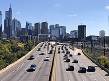
I-76 widens to six lanes and continues south near urban development, curving southeast and running between the former Philadelphia Energy Solutions oil refinery and Philadelphia Gas Works to the southwest and urban neighborhoods to the northeast and reaching an eastbound interchange for 28th Street and a westbound interchange with Vare Avenue and Mifflin Street.
The Schuylkill Expressway comes to an interchange with Passyunk and Oregon avenues that also has an eastbound exit and westbound entrance to 26th Street that provides access to PA 291 and Philadelphia International Airport.
The freeway makes a sharp turn to the east and passes under the Harrisburg Subdivision, heading near commercial areas and coming to a westbound exit and eastbound entrance with the eastern terminus of PA 291 at Penrose Avenue, providing access to Philadelphia International Airport.
The Schuylkill Expressway continues east near urban residential neighborhoods and reaches an interchange with PA 611 (Broad Street).
The freeway heads onto the seven-lane Walt Whitman Bridge, which carries it over Front Street, I-95, Conrail Shared Assets Operations' Swanson Street Industrial Track, industrial areas in the Port of Philadelphia, Christopher Columbus Boulevard, the Philadelphia Belt Line Railroad, and finally the Delaware River.
The new expressway largely followed the earlier planned parkway route from Valley Forge to Fairmount Park, while also extending into southern Philadelphia and across the Delaware River into New Jersey.
[21] PennDOT completed a scaled back version of a $23.7-million (equivalent to $32.9 million in 2023) project to add 29 webcams on the Schuylkill Expressway between the Conshohocken Curve and Passyunk Avenue.
[22] On the afternoon of June 8, 2011, a section of the Schuylkill Expressway near Grays Ferry Avenue buckled from temperatures around 100 °F (38 °C), causing lane closures.
It could also coordinate with SEPTA to provide motorists with real-time mass transit information to give commuters an option to exit the highway and use public transportation to finish their trip at some point.
[27] Mileposts and exit numbers reflect the entire length of I-76, which is concurrent with the Pennsylvania Turnpike from the Ohio state line to the Valley Forge Interchange.