Pennsylvania Route 61
PA 61 heads into commercial areas and widens to four lanes, crossing Norfolk Southern's Spruce Street Industrial Track at-grade before passing to the east of FirstEnergy Stadium, the home ballpark of Minor League Baseball's Reading Fightin Phils.
The road heads into Muhlenberg Township and becomes a divided highway as it reaches a partial cloverleaf interchange with the PA 12 freeway (Warren Street Bypass).
[3][4] Past this interchange, the route continues north into suburban areas as Pottsville Pike, a four-lane divided highway with some intersections controlled by jughandles.
PA 61 heads farther from the river and crosses under a Reading Blue Mountain and Northern Railroad line, entering industrial areas and passing west of the Ontelaunee Energy Facility.
The route becomes North Centre Avenue and passes more residences, running to the east of a Reading Blue Mountain and Northern Railroad line.
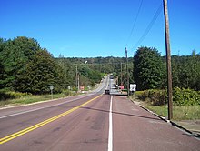
The road curves north and heads through a mix of fields and woods with some residential and commercial development to the east of the railroad tracks, with the Schuylkill River further to the west, bending northeast and entering Perry Township.
From here, the road fully enters Shoemakersville before crossing into Perry Township, heading north-northwest past homes and businesses with some farmland.
From here, the route curves northwest as an unnamed road and passes over a Reading Blue Mountain and Northern Railroad line, heading into wooded areas with the Schuylkill River to the southwest and businesses and industrial development to the northeast.
[3][5] The route becomes a four-lane divided highway with a Jersey barrier and some intersections controlled by jughandles, continuing northwest past fields and woods with some residential and commercial development.
[3][5] Farther north, the route continues through wooded areas with some development and bends northwest, intersecting Centre Street, which crosses the Schuylkill River into the borough of Mount Carbon.
PA 61 passes through a section of the borough of Palo Alto before it comes to a bridge over a Reading Blue Mountain and Northern Railroad line and enters Pottsville.
Here, the road becomes South Claude A. Lord Boulevard and passes near commercial development, crossing the Schuylkill River before coming to an intersection with US 209.
[3][5] PA 61 leaves St. Clair for New Castle Township and becomes an unnamed four-lane undivided highway that heads into forested mountains to the west of Mill Creek.
PA 61 turns northwest and the median widens as it winds north through mountainous areas, becoming Skyline Drive and crossing into Blythe Township.
[3][5] The road heads into forested mountain areas and winds to the west, passing to the north of Ashland Reservoir before gaining a second southbound lane.
The route enters the borough of Ashland and becomes South Hoffman Boulevard, passing near commercial development and curving northeast to cross a Reading Blue Mountain and Northern Railroad line at-grade and Mahanoy Creek.
[3][5] PA 61 enters Conyngham Township in Columbia County and heads northeast through dense forests as an unnamed four-lane undivided road.
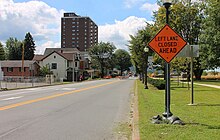
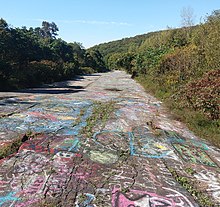
[3][6] The former divided highway alignment of PA 61 past this point has been closed because of the Centralia mine fire that has made the road unsafe to travel on.
The road leaves Centralia for Conyngham Township again and becomes an unnamed four-lane divided highway, heading through forested areas and passing to the south of a large coal mine.
The route passes north of homes in Strong as Front Street before it runs through wooded areas with some residential and commercial development.
[3][8] Following this interchange, the road continues through wooded areas and businesses, with several intersections controlled by jughandles, passing north of Marshallton.
The road fully enters Upper Augusta Township and runs through residential areas with some nearby farmland and woodland, becoming State Street.
The route passes near businesses and bends southwest, coming to an intersection with the southern terminus of southbound PA 61 Truck at Wolverton Street.
[16][17][18] US 122 was rerouted to bypass Orwigsburg to the southwest by 1940, having previously followed Brick Hill Road, Market Street, and present-day PA 443 through the town.
[31] In 2018, the Pennsylvania Department of Transportation (PennDOT) vacated ownership of the closed section of PA 61, which reverted to adjacent property owners, mostly to Pitreal Corporation, a subsidiary of Pagnotti Enterprises.
[36][37] In September 2012, PennDOT began a project to widen and improve the section of PA 61 through Deer Lake as the road saw a high accident rate.
[39][40] As part of the construction of the Central Susquehanna Valley Thruway, PA 61 is planned to continue westward from its current northern terminus, ending instead at a junction with a new limited-access roadway carrying US 15.
Northbound PA 61 Truck turns west-northwest onto one-way Arch Street, passing a mix of homes and businesses and crossing Norfolk Southern's Buffalo Line at-grade.
[8][44] The southbound truck route begins at PA 61 on the east bank of the Susquehanna River, heading east-southeast on one-way Chestnut Street.
The truck route continues southeast onto Wolverton Street, passing between homes to the north and industry to the south and curving east.