Permian Basin (North America)
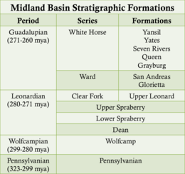
The basin contains sediment dating to Pennsylvanian, Wolfcampian (Neal Ranch and Lenox Hills Formations[7]), Leonardian (Avalon Shale), and early Guadalupian times.
[5] The San Simon Channel is a narrow syncline that separated the Central Basin Platform from the Northwestern Shelf during Leonardian and Guadalupian times.
[5] The Hovey Channel is a topographical low located on the southern edge of the Delaware Basin, allowing access to the Panthalassa sea during Guadalupian times.
[5] The Hovey Channel was originally an anticline which formed during Precambrian faulting,[8] and was the main source of sea water for the Delaware Basin.
[11] The reef complex consists of Upper Pennsylvanian Strawn, Canyon and Cisco limestones, overlain by Lower Permian Wolfcamp sandstones and shales of terrigenous origin prograding northeast to southwest.
The Tobosa Basin also contains basement rock that dates back to 1330 million years ago (mya), and that is still visible in the present-day Guadalupe Mountains.
the Montoya Group sequence is made up of carbonate limestone and dolomite which is described as dense, impermeable, and non-porous, and is more commonly found in the Glass Mountains outcrop, with thickness varying from 151 to 509 feet (46 to 155 m).
[8] During the Silurian Period, the Tobosa Basin experienced dramatic changes in sea level which led to the formation of multiple rock groups.
[19] The primary formation that remains from the Leonardian Age is called the Bone Spring Limestone, which reaches a max thickness of 2,000 feet (600 m) and lies directly below the Capitan Reef Complex.
[20] The Bone Spring Limestone consists of several fossils, such as bryozoans, crinoids, and spirifers, but lack algae and sponges that are plentiful in the rest of the Permian Reef Complex.
Rocks from the Bone Spring Limestone are predominantly found in the Delaware Basin, but the Victorio Peak Member extends into the shelf margin area.
Lasting from approximately 272–260 mya, this epoch was dominated by the Delaware Mountain Group, which can be further subdivided into rock divisions based on location in the Permian Reef Complex.
This formation reaches a maximum thickness of 1,150 feet (350 m) but thins out significantly as it approaches the basin margins due to transgressive onlap.
[21] The Brushy Canyon Formation also contains small reef patches, ripple marks, and crossed bedded strata, that indicate that the Delaware Basin had a shallow water environment at this time.
The Upper Getaway Member is more consistent and is characterised as a thick bedded dolomite which integrates into the San Andres Formation as it moves toward the shelf.
[21] The middle unit of the Cherry Canyon Formation is the South Wells Member, which is composed of sandstone and integrates itself into the Goat Seep Reef as it moves towards the basin shelf.
As these formations move towards the basin margins, the sandstone wedges out and the limestone thickens into massive, meters thick beds, containing reef talus.
The reef environment during the first stage of development was described as warm (around 68 °F (20 °C)), shallow, high energy, clear water that was free from debris and which had a normal salinity level of 27 to 40 ppt (parts per thousand).
The makeup of the reef is described as being built primarily from erect sponges, which have large, rigid skeletons, and abundant red algae, microbial micrite, and inorganic cement.
Ocean currents in the Permian played a huge role in setting up the climate of the region and for aiding in the growth and death of the Capitan Reef.
During the end of the Permian Period, the supercontinent of Pangaea was beginning its break up, which drastically changed the conditions that were previously favourable for reef growth.
Change in tectonics limited the exchange of sea water in the Hovey Channel, which then led to a salinity increase in the Permian Basin.
[25] The growing temperatures in the late Permian combined with the increase in salinity caused the extinction of the Capitan Reef, as well as the formation of evaporites with the basin.
Carbonates such as bioturbated wackstone and oxygen poor lime mud accumulate atop the underlying lowstand systems tract sandstones in the basin and on the slope.
In the early Pennsylvanian–early Permian the collision of North American and Gondwana Land (South America and Africa) caused the Hercynian orogeny.
The first commercial well was opened a year later in 1921, in the newly discovered Westbrook Oil Field in Mitchell County, at a depth of 2,498 feet (761 m).
[35]: 200–201, 230–231 [36] In 1966, the production of the Permian Basin measured 600 million barrels of oil, along with 2.3 trillion cubic ft of gas, which totaled $2 billion.
In addition to oil, one of the main commodities that is mined from the Permian Basin is potash, which was first discovered in the region in the late 1800s by geologist Johan August Udden.
Estimates from the Energy Information Administration have predicted that proven reserves in the Permian Basin still hold 5 billion barrels of oil and approximately 19 trillion cubic feet of natural gas.
[40] Satellite data show that 3.7% of gas produced from the Permian Basin is lost in leaks, equivalent to the consumption of 7 million Texas homes.