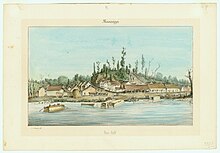
Petit Gulf
There was a settlement there prior to the 1828 organization of Rodney, Mississippi, and the Petit Gulf cotton cultivar, which was widely planted in the U.S. South before the American Civil War, was named for the landing and town.
The bluff's name referred to a small but dangerous eddy that early travelers found in the river in front of it.
[5] The east-west crossing was apparently easiest at Petit Gulf compared to any other point nearby along the river.
[6] A French traveler described the spot in 1700, "We left the Natchez and coasted along to the right, where the river is bordered with high gravelly banks for a distance of twelve leagues; at the extremity of these bluffs is a place we called Petit Gulf, on account of the whirlpool formed by the river for the distance of a quarter of a league.
[5] Travelers of 1739 described Petit Gulf's dangerous waters: "Here...we encountered for a quarter of a league extremely violent currents," and three of their eight boats ran aground on a midstream island and had to be rescued "by the efforts of a boatload of negroes which we had dispatched to their assistance.
"[13] Petit Gulf got a street survey in 1826,[5] and was shipping cotton, deer skins, and beeswax down to New Orleans via flatboat.
[15] The boundaries of the town were set as a mile square, beginning where Magnolia Street met the Mississippi River.