Pierre Peytier
Engineer geographer and geodesist, he was one of the first geodesic officers charged in 1825 with the triangulation of the Pyrenees in order to establish the map of France, together with his colleague Paul-Michel Hossard.
These true exploits went completely unnoticed at the time and many later ascensionists, believing they were achieving these ascents first, found traces of the passage of the Geodesists.
[2] The longitude and latitude of the base point at Tiryns were read and checked, so that again the margin of error was reduced as far as possible to an estimated 0.2 seconds.
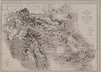
[4] However, after the departure of the scientific mission from Greece, and although he fell ill with the fever five times, Peytier remained there alone until 31 July 1831 to complete the trigonometric, topographic and statistical work for the establishment of the map of Morea.
Peytier also left an album which he himself composed with his pencil drawings, sepias and watercolours depicting city views, monuments, costumes and inhabitants of Greece at the time.
He used an artistic style that avoided idealization for the benefit of scientific fidelity and precision, which fully revealed the topographer that he was.