Erdapfel
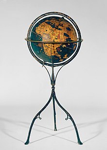
The Erdapfel (German for 'earth apple'; pronounced [ˈeːɐ̯tˌʔapfl̩] ⓘ) is a terrestrial globe 51 cm (20 in) in diameter, produced by Martin Behaim from 1490 to 1492.
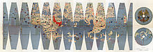
It is constructed of a laminated linen ball in two halves, reinforced with wood and overlaid with a map painted on gores by Georg Glockendon.
[1] These intricate details were based on navigational charts by Jorge de Aguiar, incorporating paper maps meticulously pasted onto a parchment layer encircling the globe.
The name is not related to the modern meaning of Erdapfel in southern Germany and Austria, which is "potato"—potatoes had not yet been brought from America to Europe.
In 1992, it was moved for some time to the Vienna University of Technology, to be studied at high resolution by the Behaim Digital Globe Project.