Tabula Rogeriana
The Nuzhat al-mushtāq fī ikhtirāq al-āfāq (Arabic: نزهة المشتاق في اختراق الآفاق, lit.
[1][2][3][4] Around 1138, the Norman King of Sicily, Roger II, invited Al-Idrisi, a Muslim geographer, to his court in Palermo, in search of help pursuing his political agenda.
Sicily's vibrant multicultural environment led al-Idrisi to accept King Roger's invitation to his court.
[5] To produce the work, Al-Idrisi started gathering information for the maps by interviewing experienced travelers on their knowledge of the world, keeping "only that part... on which there was complete agreement and seemed credible, excluding what was contradictory.
Additionally, Al-Idrisi would send out agents to the different parts of the world represented in his map to fact-check the information given by the travelers.
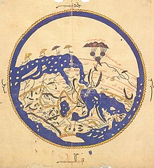
This disc was made in accordance with Al-Idrisi's calculations of the circumference of the earth, and would lead to the later creation of a silver globe with the same map engraved on it.
This reflects Roger II's desire to learn more about his domain and its surrounding areas, as well as Al-Idrisi's greater personal experience with these lands.
The work showed, in al-Idrisi's words, "the seven climatic regions, with their respective countries and districts, coasts and lands, gulfs and seas, watercourses and river mouths".
In later editions, a smaller circular world map in which the south was drawn at the top and Mecca, at the center was added to the manuscript.
This book, known as the "Little Idrisi," is still extant in multiple copies, and informs much of what scholars know today of al-Idrisi's original, extended work.
Unlike previous cartographers, al-Idrisi aimed to be as accurate as possible and to provide as much reliable information about the various regions of the world, especially those contained in Roger II's realm.
This made al-Idrisi's map one of a kind in its scope and ambitions, applying the techniques of the Balkhi School of Geography to an unprecedented scale and including detailed descriptions of all regions that it portrayed.
In 1799, in Madrid, Jose Antonio Conde reprinted the section on Andalusia in its original Arabic with a Spanish translation.
The relative position of the lakes which form the Nile, as delineated in his work, does not differ greatly from that established by Baker and Stanley more than seven hundred years afterwards, and their number is the same.
The celestial and terrestrial planisphere of silver which he constructed for his royal patron was nearly six feet in diameter, and weighed four hundred and fifty pounds; upon the one side the zodiac and the constellations, upon the other – divided for convenience into segments – the bodies of land and water, with the respective situations of the various countries, were engraved.