Potawatomi Trail of Death
Indiana governor David Wallace authorized General John Tipton to mobilize a local militia of one hundred volunteers to forcibly remove the Potawatomi from the state.
Father Benjamin Marie Petit, a Catholic missionary at Twin Lakes, joined his parishioners on their difficult journey from Indiana, across Illinois and Missouri, into Kansas.
There the Potawatomi were placed under the supervision of the local Indian agent (Jesuit) father Christian Hoecken at Saint Mary's Sugar Creek Mission, the true endpoint of the march.
[citation needed] It was also used to arrange removal of other tribes living east of the Mississippi, including several in the former Northwest Territory, south of the Great Lakes.
This treaty provided the bands under Potawatomi chiefs Menominee, Peepinohwaw, Notawkah, and Muckkahtahmoway, with a joint grant of 22 sections (14,080 acres) of reservation land.
He and his Yellow River band at Twin Lakes, Indiana, 5 miles (8.0 km) southwest of present-day Plymouth, would be forced to remove from these reservation lands on the Trail of Death to Kansas in 1838.
[12][14][15] Increased pressure from federal government negotiators, especially Colonel Abel C. Pepper, succeeded in getting the Potawatomi to sign more treaties that ceded their lands and obtained their agreement to move to reservations in the West.
Under its terms, the Potawatomi ceded the Menominee Reserve, established under an 1832 treaty, to the federal government and agreed to remove west of the Mississippi River within two years.
In exchange, the Potawatomi would receive $14,080 for the sale of their 14,080 acres of Indiana reservation lands, after payment of tribal debts were deducted from the proceeds.
[17][18][19] Chief Menominee and seventeen of the Yellow River band refused to take part in the negotiations and did not recognize the treaty's authority over their land.
[20] They sent additional petitions to President Martin Van Buren and Secretary of War Lewis Cass in 1836 and 1837, but the federal government refused to change its position.
[21][22] The following day, August 6, 1838, Col. Pepper called a council at Menominee's village at Twin Lakes, where he explained that the Potawatomi had ceded land in Indiana under the treaty, and they had to remove.
Wallace authorized General John Tipton to mobilize a militia of one hundred volunteers to forcibly remove the Potawatomi from their Indiana reservation lands.
[23][24][25] Reverend Louis Deseille, a Catholic missionary at Twin Lakes in the 1830s, denounced the Yellow River treaty of 1836 as a fraud and argued, "this band of Indians believe that they have not sold their reservation and that it will remain theirs as long as they live and their children".
[20] In response to his support of the Potawatomi's resistance efforts, Col. Pepper ordered Father Deseille to leave the mission at Twin Lakes, or risk arrest for interfering in Indian affairs.
When Makkahtahmoway, Chief Black Wolf's elderly mother, heard the soldiers firing their rifles she was so badly frightened that she hid in the nearby woods for six days.
Although Father Petit was in South Bend at the time of the militia's arrival, he later protested that the Potawatomi had been taken by surprise under "the ruse of calling a council".
[31] Between Thursday, August 30, and Monday, September 3, 1838, the day before their departure, Tipton and his militia surrounded Menominee's village at Twin Lakes, gathered the remaining Potawatomi together, and made preparations for their removal to Kansas.
[34] Father Petit closed the mission church at Menominee's village, explaining in a letter to his family dated September 14, 1838, "It is sad, I assure you, for a missionary to see a young and vigorous work expire in his arms.
[36][37] Historian Jacob Piatt Dunn is credited for naming the Potawatomi's forced march "The Trail of Death" in his book, True Indian Stories (1909).
[42][43][44] Father Petit later described the caravan in a letter to Bishop Simon Brute at Vincennes, Indiana, dated November 13, 1838, from the Osage River country of Missouri:The order of march was as follows: the United States flag, carried by a dragoon; then one of the principal officers, next the staff baggage carts, then the carriage, which during the whole trip was kept for the use of the Indian chiefs, then one or two chiefs on horseback led a line of 250 to 300 horses ridden by men, women, children in single file, after the manner of savages.
[54] Father Petit described his arrival at the camp in his journal:On Sunday, September 16, I came in sight of my Christians, under a burning noonday sun, amidst clouds of dust, marching in a line, surrounded by soldiers who were hurrying their steps.... Nearly all the children, weakened by the heat, had fallen into a state of complete languor and depression.
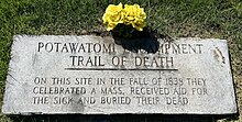
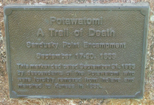
[50]After their arrival at Danville, the group traveled 6 miles (9.7 km) to Sandusky Point (which became Catlin, Illinois), where the caravan resupplied and rested from September 17–20 before continuing their journey.
In 1848 the Potawatomi moved further west to St. Marys, Kansas, 140 miles (230 km) northwest of Sugar Creek, where they remained until the Civil War.
[67][74] A metal plaque attached to a boulder marks the campsite at LaGrange, a village that no longer exists, along the Wabash River at the Tippecanoe-Warren county line.
[86][87] A plaque embedded in a boulder in Lions Club Park was erected by Boy Scout John Housman in 1993, marking the Sadorus's Grove campsite of September 22, 1838.
"[96] A marker in the town park, by a water tower, was erected in 2000 by Boy Scout Griffin Smith, and sponsored by the Gerald and Tom Wesaw families, Pokagon Potawatomi.
[citation needed] A metal plaque placed at Old State Capitol Plaza on side of building leading to the parking garage was placed by Pokagon Potawatomi in 2001.
[44][81] A marker in Foreman Grove Park, East College Avenue and Johnson Street, was erected in 2001 by Native American Fellowship Council and Bill Norval of Peoria, Illinois, and the Morgan County Historical Society.
A marker in honor of Father Benjamin Petit at St. Philippine Duchesne Park, the site of the Potawatomi's Sugar Creek Mission, includes boulders from Kansas and Missouri and a route map.