Preah Vihear Temple
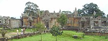
As a key edifice of the empire's spiritual life, Preah Vihear Temple was supported and modified by successive kings and thus bears elements of several architectural styles.
The temple was built at the top of Poy Tadi, a steep cliff in the Dângrêk Mountain range that is the natural border between Cambodia and Thailand.
The site is listed by Cambodia as being in Svay Chrum village, Kan Tout commune, in Choam Khsant District of Preah Vihear Province.
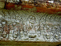
The fourth gopura is more recent, from the Khleang/Baphuon periods, and has on its southern outer pediment "one of the masterpieces of Preah Vihear" (Freeman, p. 162): a depiction of the Churning of the Sea of Milk.
The earliest surviving parts of the temple, however, date from the Koh Ker period in the early 10th century, when the empire's capital was at the city of that name.
An inscription found at the temple provides a detailed account of Suryavarman II studying sacred rituals, celebrating religious festivals, and making gifts, including white parasols, golden bowls, and elephants, to his spiritual advisor, the aged Brahmin Divakarapandita.
In 1904, Siam and the French colonial authorities ruling Cambodia formed a joint commission to demarcate their mutual border to largely follow the watershed line of the Dângrêk mountain range, which placed nearly all of Preah Vihear temple on Thailand's side.
Upstream from that point, the Mekong remains the frontier of the Kingdom of Siam, in accordance with Article 1 of the Treaty of 3 October 1893".This would deem the temple as being located within Thai territory.
However, the resulting topographic map, which was sent to Siamese authorities and used in the 1962 International Court of Justice (ICJ) ruling, showed the line deviating slightly from the watershed without explanation in the Preah Vihear area, placing all of the temples on the Cambodian side.
Cambodia protested and in 1959 asked the ICJ to rule that the temple and the surrounding land lay on Cambodian territory; the case became a volatile political issue in both countries.
The court proceedings focused not on questions of cultural heritage or on which state was the successor to the Khmer Empire, but rather on Siam's supposed longtime acceptance of the 1907 map.
Arguing in the Hague for Cambodia was former U.S. Secretary of State Dean Acheson, while Thailand's legal team included a former British attorney general, Sir Frank Soskice.
Nor did they object when a French colonial official received the Siamese scholar and government figure Prince Damrong at the temple in 1930 (possibly before the Thais realised the map was wrong).
Under the legal principle Qui tacet consentire videtur si loqui debuisset ac potuisset ("he who is silent is taken to agree"), the court ruled that Thailand had accepted and benefited from other parts of the border treaty.
[7] "Australian judge Sir Percy Spender wrote a scathing dissent for the minority on the court, however, pointing out that the French government had never mentioned Thai "acquiescence" or acceptance at any time, not even when Thailand stationed military observers at the temple in 1949.
It announced it would boycott meetings of the Southeast Asia Treaty Organization, with Thai officials saying this step was to protest a U.S. bias toward Cambodia in the dispute.
In January 1963, Cambodia formally took possession of the site in a ceremony attended by around 1,000 people, many of whom had made the arduous climb up the cliff from the Cambodian side.
Soldiers loyal to the Lon Nol government in Phnom Penh continued to hold it long after the plain below fell to communist forces.
The Khmer Rouge made several unsuccessful attempts to capture the temple, then finally succeeded on 22 May 1975 by shelling the cliff, scaling it, and routing the defenders, Thai officials reported at the time.
In December 1998, the temple was the scene of negotiations by which several hundred Khmer Rouge soldiers, said to be the last significant guerrilla force, agreed to surrender to the Phnom Penh government.
[12] The temple opened again to visitors from the Thai side at the end of 1998;[citation needed] Cambodia completed the construction of a long-awaited access road up the cliff in 2003.
[citation needed] On 12 June 1979, the government of General Kriangsak Chomanan, who had come to power in Thailand by a military coup, informed foreign embassies in Bangkok that it was going to expel a large number of Cambodian refugees.
General Kriangsak's apparent objective in this brutal operation was to demonstrate to the international community that his government would not bear alone the burden of hundreds of thousands of Cambodian refugees.
Following this, both Cambodia and Thailand were in full agreement that Preah Vihear Temple had "outstanding universal value" and should be inscribed on the World Heritage List as soon as possible.
The two nations agreed that Cambodia should propose the site for formal inscription at the 32nd session of the World Heritage Committee in 2008, with the active support of Thailand.
In response to political pressure at home, the Thai government withdrew its formal support for the listing of Preah Vihear Temple as a World Heritage site.
[23] On 5 February, in a formal letter to the U.N., Cambodia complained that "The recent Thai military actions violate the 1991 Paris Peace Accord, U.N. Charter and a 1962 judgment from the International Court of Justice".
Cambodia's military commander said: "A wing of our Preah Vihear temple has collapsed as a direct result of the Thai artillery bombardment".
[23] On 5 February, the right-wing People's Alliance for Democracy called for the resignation of Prime Minister Abhisit Vejjajiva for "failing to defend the nation's sovereignty".
[35] When visitors pass the modern entrance gate, they are faced with a steep stairway consisting of 163 steps made of large stone slabs, many of which are cut directly into the rock surface.