Protohistory of West Virginia
This was a period characterized by increased intertribal strife, rapid population decline, the abandonment of traditional life styles, and the extinction and migrations of many Native American groups.
The harsh droughts and cold winters during the Little Ice Age (sixteenth to nineteenth centuries),[2][3] put these larger groups under severe social stress as they competed for scarcer resources, such as less timber, less fertile farm land and fewer game animals.
Archaeology has also shown odd traits among the people, such as domestication of turkeys [citation needed] & the building of stone walls across certain mountain valleys.
[10] The uses of the walls are unknown, but they may have been used to control movement through the regions & seem to have also been used as traps to pen in and slaughter Forest Buffalo & other large game, according to a great deal of animal bones found at such sites.
Archaeology seems to show an influx of Siouan speaking people into the region forcing them to the northernmost reaches of their territory during the 15th & 16th centuries [11] and a possible union with the Fort Ancient culture to the west.
Archaeological cultures such as the Monongahela and Fort Ancient groups may have been confederacies whose constituent members did not all speak a common language instead of individual tribes or communities.
However, there is some evidence for a larger subbranch "Eastern Great Lakes"[14] or "Core Central", consisting of Ojibwe-Potawatomi, Miami-Illinois, Fox-Sauk-Kickapoo, and Shawnee, and excluding Cree-Montagnais and Menominee.
The tribe consisted of a number of autonomous subdivisions known as "septs" who shared a common language and culture: the Mekoche, Pekowi, Chalahgawtha, Hathawekela and Kispoko.
They are usually described as being in a near constant state of war with the Iroquois Confederacy, who were making inroads during the protohistoric period into the Ohio Valley region in a bid to control the fur trade.
"[22] Another Shawnee village known as Eskippakithiki was located on Upper Howard Creek (Kentucky River Basin) was called "kenta aki," meaning the "place of level land," by the Iroquois.
At Madisonville, intertribal trade ending in the 1610s included Basque kettle parts and Clarksdale bell type associated with the "de Soto entrada" variety of artifacts, and other.
Batts and Fallams, 1671, briefly mentions an abandoned Mohican village (Mohecan as transcribed journal entry date September 16, 1671, Summers 1929[31]) on the Kanawha-New River area.
Beginning in the late 18th century on modern maps, Big and Little Loup creeks are found opposite of Alloy bottom below the Kanawha Falls about three miles.
Delaware Chief Bull's old town, son of Teedyuscung, of Burnsville Lake Wildlife Management Area in Braxton County, dates from 1754 through 1772.
Erie populi is the earliest recognizable tribal grouping documented, including the northerly region "Riviere de la Ronceverte" of the state.
[43] They were based in the Hamilton-Niagara district of southwestern Ontario and across the Niagara River in Western New York state but had trading and war alliances with many of the surrounding Iroquoian-speaking peoples including the Petun, Huron, Wenro, Kakwa, Erie, Andasté, Massawomek and the Iroquois Confederacy.
Unlike other groups, they may have also begun to semi-domesticate white tail deer, as several early reports detail how they kept them in pens to manage them for the lucrative trade in fur and skins.
Although both peoples, the Rickahockans and later Westo, were characterized as very aggressive and warring, they were thought to be expelled from Lake Erie by the Iroquois League leaving an estimated 700 to 900 warriors to arrive in the early Virginia colonial trade area.
Linguistic and historical records indicate a possible southern origin of Siouan peoples, with migrations over a thousand years ago from North Carolina and Virginia to Ohio.
Around 1250, just prior to the Woodland II period (1350–1607), the Monacan, or Algonquian called "Mandoag", were driven by enemies from the northwest into the Piedmont James River region of Virginia.
[citation needed] Ocanahonon archaeological sites excavated between the Great Lakes and the Gulf of Mexico in the Ohio Valley have been found with both gun and knife parts.
[57] Beginning in 1675, the Yamasee were regularly recorded by the Spanish of the missionary provinces of Guale (central Georgia coast) after being pushed to northeastern Florida from the Savannah River by the Westo.
[59] In 1727, a delegation of southern Cherokee, close neighbors of the Muscogee (Creek), visiting Charleston, South Carolina referred to the Tomahitans as old enemies of their allies the Yamasee[60] of the Muskogean language.
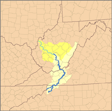
Iroquois (Tuscarora, Mingoe & Canawagh) call the anglicized Kanawha River "Ka(ih)nawáˀkye," meaning "waterway," and "kye" is an augmentive suffix.
[72] Hudson's Trading Post Inn and canoe landing, a hunter's camp, village, and archaeological mound site, appeared on Madison's 1807 map opposite St. Albans.
[74] The hills or mountains south of the Kanawha have been known by several names, including Waseoto, Osioto, Osiata, Oseoto, and Onosiota (La Posta).
They traded deer hides and byproducts to as far south as the Powhatan chiefdom on Chesapeake Bay for the prized Snow Whelk[84] (Buccinidae) marine shells.
[87] In the northern part of Chickasaw country below the confluence of the Wabash and Ohio area of the Chaouanons, Jolliet and Marquette met a band of Iroquoian origin in 1673, which they identified as either Tuscarora or Cherokee.
[95] At Le Chine in 1669 at Montreal Island,[96] La Salle was told to expect to find Chaouanon (Algonquian) and Honniasontkeronon (Iroquois) villages on the Ohio above the falls or above Louisville, Kentucky.
It was still closer to Tutelo groups, elemental Swanton's Toteras of interest, and its nearby Monacan east of Roanoke area and Kanawhan Monetons following Wood's 1674 contact.