Pumsaint
The name is derived from the stone block at the nearby gold mines, opposite Ogofau Lodge, which has four sides, each of which has hollows probably caused by pestle impacts.
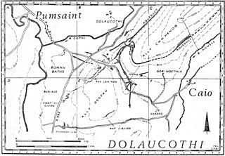
During his tenure, he probably established the fort at Pumsaint in west Wales, largely to exploit the gold deposits at Dolaucothi.
Objects found included a wheel brooch and snake bracelets, so named because they were soft enough to be coiled around the arm for display.
The Romans made extensive use of water carried by several aqueducts and leats (the longest of which is about 7 miles (11 km) from its source in a gorge of the river) to prospect for the gold veins hidden beneath the soil on the hillsides above the modern village of Pumsaint.
The water was used in a method known as hushing, where a wave is released to sweep soil and sub-soil away to reveal bare rock.
Other places of interest include the National trust Visitor Centre, located in the Old Coach House in the centre of the village, where displays of the local dolaucothi estate history is displayed along with information on the oak woodlands, the traditional nesting place of the red kite, may be viewed.