Pushmataha County, Oklahoma
During prehistoric times, Pushmataha County was part of the territory during the Middle Woodland period of the Fourche Maline culture.
The elite organized the construction of complex earthwork mounds for burial and ritual ceremonial purposes, arranged around a large plaza that had been carefully graded.
In the 16th century, European explorers began to enter the North American interior, seeking fame, treasures, and conquests on behalf of their empires.
De la Harpe's exploration of the Mississippi River valley was part of an effort to seek trade with the native peoples and also a route to New Mexico.
[5] The area that became Pushmataha County was bought by the United States from France as part of the large Louisiana Purchase in 1803.
Fortifying the frontier from Spanish incursion, and securing it against potential uprisings by American Indians, was important to United States policy.
[9] During the American Civil War federal troops withdrew from the Indian Territory and the Choctaw Nation allied itself with the Confederate States of America.
He was then working at Spencer Academy, a Choctaw Nation boarding school located at Spencervile, Indian Territory.
As a result, the territory comprising modern-day Pushmataha County was still virgin wilderness decades after the Choctaws’ arrival.
The federal government granted the railroad rights-of-way in Indian Territory to stimulate development and attract European-American settlers.
Workers moved and shaped huge amounts of earth to form its elevated roadbed, and constructed numerous wooden trestles over creeks and rivers.
Once in place the railroad attracted commerce and industry, where white men in the Indian Territory hoped to stake a claim.
A group of leaders from the Five Civilized Nations – Choctaw, Cherokee, Chickasaw, Creek, and Seminole – met at Muskogee in an attempt to seize the initiative and fashion a state from the Indian Territory, a jurisdiction to be controlled by Native Americans.
[12] The leaders meeting in Muskogee recognized that the counties of the Choctaw Nation, drawn to reflect easily recognizable natural landmarks such as mountain ranges and rivers, were not economically viable.
County boundaries for the new State of Sequoyah were crafted to take into account the existing towns and the range of their commercial interests.
Local residents believed the soil to be fertile and the weather enviable and moderate; it seemed that almost any fruit or vegetable could be grown.
[14] Early business leaders at statehood immediately sought to fund public improvements by asking local voters to pass bonds.
The fourteen soldiers were part of a pioneering use of American Indian languages as military code during war, to enable secret communications among the Allies.
[15] Federal government programs developed by the administration of President Franklin D. Roosevelt during the Great Depression of the 1930s brought substantial improvements and infrastructure to the county: the federal Works Progress Administration (or WPA) directed the construction with local workers of handsome, sturdy schools and school gymnasiums in numerous communities.
Architectural design changed, as stores, churches and homes no longer had to allow for maximum ventilation via the free flow of air from open windows and doors.
Wholesale changes resulted from railroad restructuring in the later 20th century, and the Frisco ended freight operations in the early 1980s.
The Indian Nation Turnpike, which opened in 1970, had only one interchange in all of Pushmataha County, at Antlers, connecting residents to freeway travel to Oklahoma City and Tulsa.
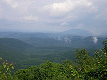
The mountains are difficult to penetrate with road construction and large areas of the county are virtually empty of population.
Sardis Lake, a flood-control facility in the northeastern part of the county, impounds the waters of Jack Fork Creek.
A very small portion of the southwest corner of Pushmataha County features Lamey Slash, an area of wetlands which drains into Muddy Boggy Creek.
Its easternmost area, in the vicinity of Honobia and north of Cloudy, receives approximately 52 inches of rain per year.
Modern-day residents are protected by a civil defense system consisting of "storm spotters" stationed throughout the populated areas during threatening weather, observing the skies for signs of rotations or funnels.
In Antlers a system of three public-alert sirens sounds the alarm when a funnel is spotted, allowing residents to seek shelter.
For a time these were economically successful, even at Jumbo, which experienced a catastrophic mine explosion in 1910 which killed numerous miners.
During the Twentieth Century a rapidly improving transportation network enabled Pushmataha County to advance economically.