Quitobaquito Springs
It lies at an elevation of 1,152 feet (351 m), west of the south end of the Quitobaquito Hills, along the border of the United States with Mexico.
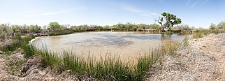
[1] The only US populations of the endangered Quitobaquito pupfish, the Sonoyta mud turtle, the desert caper, and the Howarth's white butterfly are found here.
El Camino del Diablo trail established by de Anza from Sonora to Alta California used and passed through the area of the spring which provided a trail for subsequent travelers between Sonora and California into the later 19th century.
[1][5] The famous pond fed by the springs was built in the 1860s, and has a clay liner that requires frequent upkeep.
It has been speculated that this drop may be due to overdrafting by farmers in Sonoyta as well as the summer heat, but others suspect that the drop may be due to the construction of the Mexico–United States border wall nearby, which could have caused cracks in the pond's lining, causing water leakage, as well as excessive pumping of groundwater to create concrete for the wall.