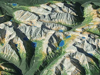
Raised-relief map
Joseph Needham suggests that certain pottery vessels of the Han dynasty (202 BCE – 220 CE) showing artificial mountains as lid decorations may have influenced the raised-relief map.
[1] The Han dynasty general Ma Yuan made a raised-relief map of valleys and mountains in a rice-constructed model of 32 CE.
A raised-relief map made of wood representing all the provinces of the empire and put together like a giant 0.93 m2 (10 ft2) jigsaw puzzle was invented by Xie Zhuang (421–466) during the Liu Song dynasty (420–479).
Shen Kuo (1031-1095) created a raised-relief map using sawdust, wood, beeswax, and wheat paste.
[5] The map, made of eight pieces of wood connected by hinges, could be folded up and carried around by one person.
[6] In his 1665 paper for the Philosophical Transactions of the Royal Society, John Evelyn (1620–1706) believed that wax models imitating nature and bas relief maps were something entirely new from France.
A combination of computer numerical control (CNC) machining a master model, and vacuum forming copies from this, can be been used to rapidly mass-produce raised-relief maps.
They are not good at representing sharp-edged land forms like high mountain ranges or urban areas.
After the model is created, color can be added to show different land cover characteristics, providing a more realistic view of the area.
[9] Creating a papercraft raised relief map via a Digital Elevation Model (DEM) is a low cost alternative to many other methods.
[10] This method allows raised relief maps to be constructed without the need for specialized equipment or extensive training.