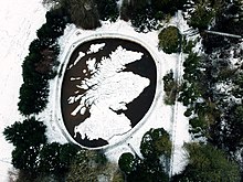
Great Polish Map of Scotland
The brainchild of Polish war veteran Jan Tomasik, it was built between 1974 and 1979 and is claimed to be the world's largest terrain relief model.
[4] The Poles strengthened existing defences by installing anti-tank obstacles, building pill boxes and patrolling the coastline in armoured trains.
[8] The large concrete map of Scotland (with the omission of the remote Northern Isles) was the idea of Jan Tomasik, a sergeant in the 1st Armoured Division, who during the war had been stationed in Galashiels, about 14 miles (22 km) from the castle.
In the early 1960s, finding his old wartime commander, like all Polish veterans, denied a war pension as a non-UK citizen, Tomasik employed Maczek in various jobs, including barman, in his Edinburgh hotel.
[9] A friendship developed between the two men, and in the 1970s Tomasik provided a room for Maczek to enjoy summer breaks with his family in his newly refurbished hotel at Barony Castle.
It is known that Polish soldiers created an outline map of Poland on the ground at Douglas in Lanarkshire in 1940,[10] in the very camp where Tomasik was stationed after arriving in Britain.
However, he is also on record as having said to hotel patrons that he wanted to show the country the Poles had defended during the war and was planning to invite George VI's consort Queen Elizabeth to open the map officially.
[12] In the following summer, Tomasik revisited Poland, returning with Trafas, Wolnik and three Kraków University employees hired under contract to provide the manual labour to construct the concrete map.
Mountain summits were marked by vertical rods, their heights exaggerated five times relative to the horizontal scale to increase the visual effect.
[3] After the last visit of the Polish cartographers in 1977, hotel employees and members of the Tomasik family continued to work on the map intermittently over two more summers before it was completed in 1979.
[12] After the sale of the hotel in 1985, parts of the map deteriorated slowly over the years due to vegetation growth, root and frost damage and water supply blockage.
[15] In May 2012, the MSP for Midlothian South, Tweeddale and Lauderdale, Christine Grahame, proposed a parliamentary motion (which was debated in September 2012) that the Scottish Parliament should recognise "the historic significance of The Great Polish Map of Scotland"[17] and support the project.
[1][20] It exceeds the surface area of the solid terrain model of British Columbia in the Crystal Garden, Victoria—74 by 40 feet (23 m × 12 m)—claimed to be the largest in the world[22] (Mapa Scotland point out that the Scottish map is 2.8 times larger[20]).