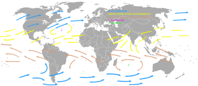
Westerlies
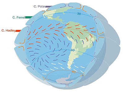
They originate from the high-pressure areas in the horse latitudes (about 30 degrees) and trend towards the poles and steer extratropical cyclones in this general manner.
The westerlies play an important role in carrying the warm, equatorial waters and winds to the western coasts of continents, especially in the southern hemisphere because of its vast oceanic expanse.
If the Earth were tidally locked to the Sun, solar heating would cause winds across the mid-latitudes to blow in a poleward direction, away from the subtropical ridge.
[7] An example of the impact of the westerlies is when dust plumes, originating in the Gobi Desert combine with pollutants and spread large distances downwind, or eastward, into North America.
[8] The westerlies can be particularly strong, especially in the Southern Hemisphere, where there is less land in the middle to cause the progression of west to east winds to slow down.
In the Southern hemisphere, because of the stormy and cloudy conditions, it is usual to refer to the westerlies as the roaring forties, furious fifties, or shrieking sixties according to the varying degrees of latitude.
[12] In the northern hemisphere, the Gulf Stream, part of the North Atlantic Subtropical Gyre, has led to the development of strong cyclones of all types at the base of the Westerlies, both within the atmosphere and within the ocean.
An extratropical cyclone is a synoptic scale low-pressure weather system that has neither tropical nor polar characteristics, being connected with fronts and horizontal gradients in temperature and dew point otherwise known as "baroclinic zones".