Rhyolite, Nevada
It is in the Bullfrog Hills, about 120 miles (190 km) northwest of Las Vegas, near the eastern boundary of Death Valley National Park.
During an ensuing gold rush, thousands of gold-seekers, developers, miners and service providers flocked to the Bullfrog Mining District.
Many settled in Rhyolite, which lay in a sheltered desert basin near the region's biggest producer, the Montgomery Shoshone Mine.
By 1907, Rhyolite had electric lights, water mains, telephones, newspapers, a hospital, a school, an opera house, and a stock exchange.
Published estimates of the town's peak population vary widely, but scholarly sources generally place it in a range between 3,500 and 5,000 in 1907–08.
From 1988 to 1998, three companies operated a profitable open-pit mine at the base of Ladd Mountain, about 1 mile (1.6 km) south of Rhyolite.
The town is named for rhyolite, an igneous rock composed of light-colored silicates, usually buff to pink and occasionally light gray.
As quoted by Robert D. McCracken in A History of Beatty, Nevada, Harris said during a 1930 interview for Westways magazine, "The rock was green, almost like turquoise, spotted with big chunks of yellow metal, and looked a lot like the back of a frog.
The total population of these camps was 29, and because game was scarce, they subsisted largely on seeds, bulbs and plants gathered throughout the region, including the Bullfrog Hills.
[19] Sawtooth Mountain, the highest point in the Bullfrog Hills, rises to 6,002 feet (1,829 m) above sea level about 3 miles (4.8 km) northwest of Rhyolite.
[16] Nevada's main climatic features are bright sunshine, low annual precipitation, heavy snowfall in the higher mountains, clean, dry air, and large daily temperature ranges.
[19] On August 9, 1904, Cross and Harris found gold on the south side of a southwestern Nevada hill later called Bullfrog Mountain.
[27] Word of the discovery spread to Tonopah and beyond, and soon thousands of hopeful prospectors and speculators rushed to what became known as the Bullfrog Mining District.
Rival auto lines ferried people between Rhyolite and Goldfield and the rail station in Las Vegas in Pope-Toledos, White Steamers, and other touring cars.
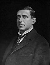
[29] Ernest Alexander "Bob" Montgomery, the original owner, and his partners sold the mine to industrialist Charles M. Schwab in February 1906.
[31] Schwab expanded the operation on a grand scale, hiring workers, opening new tunnels and drifts, and building a huge mill to process the ore.
[35] Alan H. Patera in Rhyolite: The Boom Years states published estimates of the peak population have been "as high as 6,000 or 8,000, but the town itself never claimed more than 3,500 through its newspapers".
[36] Rhyolite in 1907 had concrete sidewalks, electric lights, water mains, telephone and telegraph lines, daily and weekly newspapers, a monthly magazine, police and fire departments, a hospital, school, train station and railway depot, at least three banks, a stock exchange, an opera house, a public swimming pool and two formal church buildings.
[34] Another building housed the Rhyolite Mining Stock Exchange, which opened on March 25, 1907, with 125 members, including brokers from New York, Philadelphia, Los Angeles, and other large cities.
As mines in the district reduced production or closed, unemployed miners left Rhyolite to seek work elsewhere, businesses failed, and by 1910, the census reported only 675 residents.
The post office closed in November 1913; the last train left Rhyolite Station in July 1914, and the Nevada-California Power Company turned off the electricity and removed its lines in 1916.
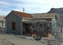
[47] Ruins include the railroad depot and other buildings, and the Bottle House, which the Famous Players Lasky Corporation, the parent of Paramount Pictures, restored in 1925 for the filming of a silent movie, The Air Mail.
[51] Tourism flourished in and near Death Valley in the 1920s, and souvenir sellers set up tables in Rhyolite to sell rocks and bottles on weekends.
[51] In 1984, Belgian artist Albert Szukalski created his sculpture The Last Supper on Golden Street near the Rhyolite railway depot.
[54] The art became part of the Goldwell Open Air Museum, an outdoor sculpture park near the southern entrance to the ghost town.
A company known as Bond Gold built an open-pit mine and mill at the site, about 1 mile (1.6 km) south of Rhyolite along State Route 374.