Places of interest in the Death Valley area
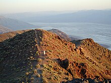
Aguereberry Point /ˈæ.ɡər.ˌbɛr.i/[1] is a promontory and tourist viewpoint in the Panamint Range, within Death Valley National Park in Inyo County, eastern California.
The point's elevation reaches 6,433 ft and is named for Jean Pierre "Pete" Aguereberry, a Basque miner who was born in 1874, emigrated from France in 1890, and lived at and worked the nearby Eureka Mine from 1905 to his death in 1945.
In the 1930s, geologist Levi F. Noble studied the faulting and folding in the area, dubbing it the "Amargosa chaos" due to the extreme warping of the rock.
The second event began while layered younger Precambrian sediments were being deposited on top of the beveled surface of older metamorphic basement rocks.
The two events responsible for the chaotic appearance of the Amargosa Chaos did not occur until over half a billion years later, during Mesozoic or Early Tertiary time.
This phase of deformation coincided with severe crustal stretching that created the deep valleys and high mountains of this part of the Basin and Range Province.
Called the Artist Drive Formation, the rock unit provides evidence for one of the Death Valley area's most violently explosive volcanic periods.
The Badwater Basin is a salt flat adjacent to the Black Mountains that descends to the lowest elevation in North America at 282 feet (86 m)[4] below sea level.
Unlike at the Devils Golf Course, significant rainstorms flood Badwater, covering the salt pan with a thin sheet of standing water.
This, the nation's greatest evaporation potential, means that even a 12-foot (3.7 m) deep, 30 miles (48 km) long lake would dry up in a single year.
The kilns were located here as the trees single-leaf pinyon pine (Pinus monophylla) and Utah juniper (Juniperus osteosperma) dominate the landscape in the upper Panamint Mountains.
Darwin Falls is a waterfall located on the western edge of Death Valley National Park near the settlement of Panamint Springs, California.
The small, narrow valley where the creek and falls are located features a rare collection of riparian greenery in the vast desert and is home to indigenous fauna such as quail.
With an elevation several feet above the valley floor at Badwater, the Devil's Golf Course remains dry, allowing weathering processes to sculpt the salt there into complicated formations.
Through exploratory holes drilled by the Pacific Coast Borax Company, prior to Death Valley becoming a national monument in 1934, it was discovered that the salt and gravel beds of the Devil's Golf Course extend to a depth of more than 1,000 feet (300 m).
Controversy surrounds the use of Furnace Creek water to support the resort (complete with a swimming pool) and nearby facilities, including a golf course.
The scarce springs and surrounding lush oases support thriving plant communities and attract a wide variety of animals.
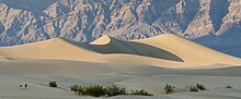
The tiny grains of quartz and feldspar that form the sinuous sculptures that make up this dune field began as much larger pieces of solid rock.
The canyon follows faults that formed when the rocky crust of the Death Valley region began stretching just a few million years ago.
Periodic flash floods carry rocky debris (sediment) eroded from Mosaic Canyon and the surrounding hillsides toward the valley below.
At the canyon mouth water spreads out and deposits its sediment load, gradually building up a large wedge-shaped alluvial fan that extends down toward Stovepipe Wells.
These rock formation began as limestone deposited during Late Precambrian (about 850–700 million years ago) when the area was covered by a warm sea.
Located four miles (6.4 km) south of the Artist's Drive scenic loop, the canyon contains a natural stone bridge, accessible after a fifteen-minute walk from the parking area.
During periods of heavy rain, water washes down from nearby mountain slopes onto the playa, forming a shallow, short-lived lake.
Formed of steep cliffs, it is composed of red colored oxidized rocks and is visible from Zabriskie point and the Golden Canyon trail.
The wetland lies at the southern tip of the Ibex Hills, on the floor of Death Valley and just northeast of the Amargosa River.
Several springs overflow into pools totaling 6.6 acres (2.7 ha) in area, making the site the third largest marsh in the park.
The area saw a failed nitrate rush in 1902, and similarly unsuccessful attempts to mine gold and silver in the middle part of the decade.
A dirt road provides access to an overlook of the area, but human entry into the wetland itself is prohibited in order to the protect the sensitive habitat.
As groundwater exploded into steam due to the heat of magma underneath, an empty pit was left behind and the debris spread around the field.