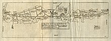
River Ancholme
It rises at Ancholme Head, a spring just north of the village of Ingham[1] and immediately west of the Roman Road, Ermine Street.
Further improvements were started by John Rennie (the Elder) in the early 1800s and completed by his son in the 1820s, with the reconstruction of Ferriby Sluice taking place around 1841.
Some bridges are private rights of way – remaining such as conscious of the risk of driver shortcutting and over-use – many such are listed (statutorily protected for architectural merit or age).
In its natural post-glacial state, the river's valley was flat-bottomed: it had formed the bed of the glacial Lake Ancholme, on an outwash delta, as the ice retreated,[3] and consequently was fenny.
Professor McGrail conducted a re-excavation of the site in 1974, to discover the bottom of a flat-bottomed boat, made from oak planks, sewn together and caulked with moss.
The oldest find in the parish was a Paleolithic handaxe discovered close to the site of the Harlam Hill Lock on a hummock of river gravels.
[7] Despite suffering from silting as a result of water from the Humber entering it, and passing through land which was often waterlogged on both sides, the Ancholme offered a route into the communities of northern Lincolnshire.
However, the major concern of the local landowners seems to have been that it should act as an effective drainage channel to prevent inundation of their lands, and between 1289 and 1418 the river was mentioned in the Patent Rolls thirteen times.
The draining of the Ancholme Level was a lesser project among the fenland "improvements" undertaken under contracts to patentees by the government of Charles I in the 1630s.
"[10] The antiquarian William Stukeley visited the river and in 1724 published a report in which he lamented the fact that the sluices below the stately bridge were "broken down and lying in dismal ruins by the negligence of the undertakers."
The minutes of the commissioners show that their major concern was with drainage, rather than navigation, although the new sluice at Ferriby included a 70 by 14.75 ft (21.34 by 4.50 m) lock and a house for the lockkeeper.
[14] The commissioners gradually realised that navigation might be beneficial, and on 7 April 1778 instructed their engineer, Dunderdale, to design a wharf for coal and general goods at Bishopbridge, and to construct a lock at Harlam Hill.
[15] During the 1790s, the problems of effective drainage worsened, and the commissioners appointed Isaac Leatham, from Barton near Malton, to produce a comprehensive report with recommendations for the Ancholme Level.
After the project engineer, Samuel Porter, died in July 1808, the work ground to a halt, and in 1824 Sir John Rennie (the Younger) was asked for advice.
He also recommended that the Ferriby sluice should be reconstructed, with the sills 8 feet (2.4 m) lower, and that the capacity of the channel should be doubled, by making it wider and deeper.
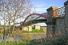
The bridge at Brandy Wharf, which was completed in the following year, is more typical of the structures built at that time, consisting of an iron span with stone abutments.
The lock was spanned by a swing bridge, cast by the Butterley Company, which was in use for 90 years, but was badly damaged in 1934 when a large vessel ran into it.
[22] The navigation became an important route for transporting cargo from the rural communities to the towns of Beverley and Hull in the East Riding of Yorkshire.
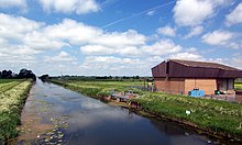
Bishopbridge, where there was a basin, two corn mills and warehousing, acted as a distribution and collection centre for the farms and villages of that part of Lincolnshire, but by the 1970s commercial traffic had ceased except between Ferriby and Brigg,[25] where there were factories along the river bank.
By the early 1980s, the scheme had grown to include further links to Horncastle and the Foss Dyke, thus creating a northern Lincolnshire waterways network, but the area was too sparsely populated for such ambitious plans to succeed.
The Ancholme Head race covers a 2,750-metre (3,010 yd) course, with open, women's, juniors, mixed and masters categories, and is affiliated to British Rowing.
Extractions from the underlying chalk aquifer could not be increased, and so the demand was met by building the Trent Witham Ancholme Transfer Scheme (TWA), which was commissioned in 1974.
British Steel take water for the Scunthorpe Steelworks from a pumping station immediately to the north of Worlaby railway bridge.
Water is also processed by a treatment plant, where it is filtered and ion-exchanged, to provide a clean supply for the boilers, which will not cause scaling or corrosion.
After initial grit removal and chlorination, water is pumped for 1.2 miles (1.9 km) through twin 5.9-foot (1.8 m) diameter concrete pipelines to Cadney reservoir, which can hold 900 megalitres (200×10^6 imp gal), covers 35 acres (14 ha), and has a maximum depth of 36 feet (11 m).
[55] The Ancholme rises near Top Farm, West Firsby, close to the 40-metre (130 ft) contour, from where it flows eastwards, gradually turning towards the north east.
Contributions from a number of organisations and individuals resulted in the purchase of a "wheelyboat", a flat-bottomed boat which allows wheelchair users to access the water.
A little further to the east is the Old Tollgate Bridge, a red brick single span with ashlar dressing dating from the late 1700s, which crosses the Old River Ancholme.
[65] Hibaldstow Bridge was rebuilt in 1889 to a design by Alfred Atkinson, and the wrought-iron span, which rests on brick piers, was supplied by a company of ironfounders called Messrs Porter and Co of Lincoln.
Salinity in the river is further controlled by two bubble curtains, and is continuously measured at Saxby, with the information used to decide whether the flow should be supplemented by water from the Trent Witham Ancholme Transfer Scheme.