Congo River
Measured along with the Lualaba, the main tributary, the Congo River has a total length of 4,370 km (2,720 mi).
[2] The river transports annually 86 million tonnes of suspended sediment to the Atlantic Ocean and an additional 6% of bedload.
[10][16] Because its drainage basin includes areas both north and south of the Equator, its flow is stable, as there is always at least one part of the river experiencing a rainy season.
The Kwilu River originates in the hills near the Angolan border and enters the Congo some 100 km upstream from Matadi.
The other is the Inkisi River, that flows in a northerly direction from the Uíge Province in Angola to the confluence with the Congo at Zongo some 80 km (50 mi) downstream from the twin capitals.
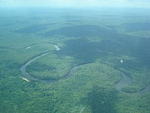
Because of the vast number of rapids, in particular the Livingstone Falls, this section of the river is not operated continuously by riverboats.
[25] Railways now bypass the three major falls, and much of the trade of Central Africa passes along the river, including copper, palm oil (as kernels), sugar, coffee, and cotton.
[28] The plan (as originally conceived) called for the construction of five dams that would have had a total generating capacity of 34,500 megawatts (MW).
[27] In February 2005, South Africa's state-owned power company, Eskom, announced a proposal to expand generation through improvements and the construction of a new hydroelectric dam.
[37][38] In terms of aquatic life, the Congo River Basin has a very high species richness and among the highest known densities of endemics.
[39] As of 2009[update], almost 800 fish species have been recorded from the Congo River Basin (not counting Lake Tanganyika, which is connected but ecologically very different),[40] and large sections remain virtually unstudied.
[43] The Congo has by far the highest diversity of any African river system; in comparison, the next richest are the Niger, Volta and Nile with about 240, 140 and 130 fish species, respectively.
Three of the more unusual endemics are the whitish (non-pigmented) and blind Lamprologus lethops, which is believed to live as deep as 160 metres (520 ft) below the surface,[30] Heterochromis multidens, which is more closely related to cichlids of the Americas than other African cichlids,[48] and Caecobarbus geertsii, the only known cavefish in Central Africa.
Remnants of the aboriginal population displaced by the Bantu migration, Pygmies/Abatwa of the Ubangian phylum, remain in the remote forest areas of the Congo Basin.
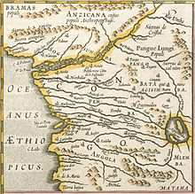
In the east were the Seven Kingdoms of Kongo dia Nlaza, considered to be the oldest and most powerful, which likely included Nsundi, Mbata, Mpangu, and possibly Kundi and Okanga.
Its territorial control along the river remained limited to what corresponds to the modern Kongo Central province.
The extreme northeast of the Congo basin was reached by the Nilotic expansion at some point between the 15th and 18th centuries, by the ancestors of the Southern Luo speaking Alur people.
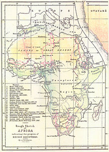
[53] Livingstone proposed to prove that the Lualaba connected to the Nile, but on 15 July, he witnessed a massacre of about 400 Africans by Arab slavers in Nyangwe, which experience left him too horrified and shattered to continue his mission to find the sources of the Nile, so he turned back to Lake Tanganyika.
Overland he reached Nyangwe, the center of a lawless area containing cannibal tribes at which Tippu Tip based his trade in slaves.
Since the going through the forest was so heavy, Tippu Tip turned around with his party on December 28, leaving Stanley on his own, with 143 people, including eight children and 16 women.
In total Stanley reports 32 unfriendly meetings on the river, some violent, even though he attempted to negotiate a peaceful thoroughfare.
Here Stanley learned that the river was called Ikuta Yacongo,[57] proving to him that he had reached the Congo and that the Lualaba did not feed the Nile.
Most probably (Stanley's own publications give inconsistent figures), he lost 132 people through disease, hunger, drowning, killing and desertion.
[58][59] Kinshasa was founded as a trading post by Stanley in 1881 and named Léopoldville in honor of Leopold II of Belgium.