Robert de Vaugondy
Gilles and Didier Robert De Vaugondy produced their maps and terrestrial globes working together as father and son.
Globes of a variety of sizes were made by gluing copperplate-printed gores on a plaster-finished papier-mache core, a complicated and expensive manufacturing process, employing several specialists.
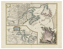
From him, they inherited much of Sanson's cartographic material, which they combined with maps and plates acquired after Hubert Jaillot's death in 1712 to form the basis the Atlas Universel.
Sources from the Dépôt de la Marine, the official French repository for maritime-related information, were used for their maps of Canada and South America.
Like Ortelius and Mercator, the Vaugondy's credited their sources, which has greatly benefited the study of the history of cartography during that period.